IMAGES TAKEN NEAR TO
Middle Street, BRIGHTON, BN41 1DP
Introduction
This page details the photographs taken nearby to Middle Street, BN41 1DP by members of the Geograph project.
The Geograph project started in 2005 with the aim of publishing, organising and preserving representative images for every square kilometre of Great Britain, Ireland and the Isle of Man.

There are currently over 7.5m images from over14,400 individuals and you can help contribute to the project by visiting https://www.geograph.org.uk
Image Map
Images are licensed for reuse under creativecommons.org/licenses/by-sa/2.0
Notes
- Clicking on the map will re-center to the selected point.
- The higher the marker number, the further away the image location is from the centre of the postcode.
Image Listing (144 Images Found)
Images are licensed for reuse under creativecommons.org/licenses/by-sa/2.0
Image
Details
Distance
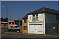
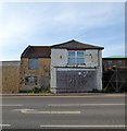
1
Derelict Shop, Wellington Road
Another remainder of the former residential district that was cleared in the 1950s. Near the junction with Church Road (B2139).
Image: © Simon Carey
Taken: 9 Dec 2007
0.01 miles
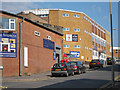
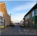
2
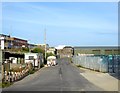
Middle Street
Small side street linking Wellington Road to North Street. The area here was once known as Copperas Gap and a small residential district sprung up during the Victorian period to service the growing industries based around the new port of Shoreham. Officially renamed as Portslade by Sea in 1896 the community persisted until the 1960s when many of the small terraced houses were pulled down and replaced with industrial units.
Image: © Simon Carey
Taken: 2 Dec 2010
0.01 miles
3
Firewood Depot, Wellington Road, Portslade, Sussex
Probably a combination of depot, and office, this building appears to have come back into use since 2007.
The adjacent advertisement is for a televised pre-election 2010 debate, bringing together party leaders Gordon Brown (Lab), David Cameron (Con) and Nick Clegg (Lib Dem). The 2010 General Election campaign saw televised leader debates, for the first time, in the UK.
Image
Image: © Peter Trimming
Taken: 17 Apr 2010
0.02 miles
4
Middle Street, Portslade-By-Sea
Small street linking North Street to Wellington Road, the A259. The area between Station Road in the east, Church Road in the west and St Andrew's Road to north was once a community of tight knit terraced housing that made up the settlement of Portslade-By-Sea. The vast majority were demolished in the 1950s as slum housing and the area given over to business units and small factories. Only a few houses on the southern side of the A259 along with Albion Street remain of the former district.
Image: © Simon Carey
Taken: 17 May 2020
0.02 miles
5
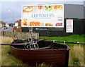
The Portslade Gassie
A memorial to the ferry service that once ran from the northern shore of The Canal to Portslade Gas Works on the southern side. The rowing boat was the quickest way for workers living in Portslade-by-Sea to cross over to work saving a forty minute walking journey around the eastern end of the basin. The memorial is on the junction of Wellington Road (A259) and Church Road (b2139), the latter can be seen in the background.
Image: © Simon Carey
Taken: 9 Dec 2007
0.02 miles
6
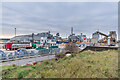
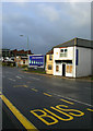
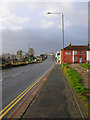
Basin Road North
Looking down from Wellington Street onto Basin Road North, serving Shoreham Harbour.
Image: © Ian Capper
Taken: 21 Jan 2022
0.02 miles
7
95, Wellington Road, Portslade-By-Sea
A rare surviving house from the days when Portslade-By-sea was a small residential community. The vast majority of the housing was pulled down during the 1950s and replaced by industrial and business units. The current building forms part of a garage that is accessed via Church Road.
Image: © Simon Carey
Taken: 17 May 2020
0.03 miles
8
Basin Road North, Portslade-By-Sea
A continuation of Basin Road North, Aldrington despite the fact the roads do not join up. Access is via the A259 with the road serving Britannia Wharf and Baltic Wharf.
Image: © Simon Carey
Taken: 17 May 2020
0.03 miles
9
Copperas Gap
Once a dip in the cliffs allowing access to then River Adur for the villagers of Portslade. Also a popular landing place for smugglers before the area became built up. Later became the site of a small ferry to the gas works on the far side of the canal. Now the junction of Wellington Road (A259) and Church Road (B2139).
Image: © Simon Carey
Taken: 9 Dec 2007
0.03 miles