IMAGES TAKEN NEAR TO
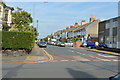
St. Andrews Road, BRIGHTON, BN41 1DB
Introduction
This page details the photographs taken nearby to St. Andrews Road, BN41 1DB by members of the Geograph project.
The Geograph project started in 2005 with the aim of publishing, organising and preserving representative images for every square kilometre of Great Britain, Ireland and the Isle of Man.

There are currently over 7.5m images from over14,400 individuals and you can help contribute to the project by visiting https://www.geograph.org.uk
Image Map
Images are licensed for reuse under creativecommons.org/licenses/by-sa/2.0
Notes
- Clicking on the map will re-center to the selected point.
- The higher the marker number, the further away the image location is from the centre of the postcode.
Image Listing (132 Images Found)
Images are licensed for reuse under creativecommons.org/licenses/by-sa/2.0
Image
Details
Distance
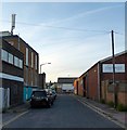
1
Ellen Street
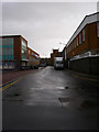
Another former residential street now flanked by two warehouses.
Image: © Simon Carey
Taken: 9 Dec 2007
0.04 miles
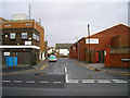
2
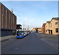
East Street, Portslade-By-Sea
A cul-de-sac heading north from North Street.
The area between Station Road in the east, Church Road in the west and St Andrew's Road to north was once a community of tight knit terraced housing that made up the settlement of Portslade-By-Sea. The vast majority were demolished in the 1950s as slum housing and the area given over to business units and small factories. Only a few houses on the southern side of the A259 along with Albion Street remain of the former district.
Image: © Simon Carey
Taken: 17 May 2020
0.07 miles
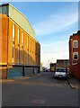
3
East Street
Another former residential street now lined with warehouses.
Image: © Simon Carey
Taken: 9 Dec 2007
0.07 miles
4
George Street, Portslade-By-Sea
Small street heading northwards from North Street before turning west and becoming Ellen Street. Pretty much all of the street is in view.
The area between Station Road in the east, Church Road in the west and St Andrew's Road to north was once a community of tight-knit terraced housing that made up the settlement of Portslade-By-Sea. The vast majority were demolished in the 1950s as slum housing and the area given over to business units and small factories. Only a few houses on the southern side of the A259 along with Albion Street remain of the former district.
Image: © Simon Carey
Taken: 17 May 2020
0.07 miles
5
West Street, Portslade-By-Sea
Heading northwards from North Street before turning east and becoming Ellen Street.
The area between Station Road in the east, Church Road in the west and St Andrew's Road to north was once a community of tight knit terraced housing that made up the settlement of Portslade-By-Sea. The vast majority were demolished in the 1950s as slum housing and the area given over to business units and small factories. Only a few houses on the southern side of the A259 along with Albion Street remain of the former district.
Image: © Simon Carey
Taken: 17 May 2020
0.07 miles
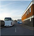
7
North Street, Portslade-By-Sea
Linking Church Road, the A293, in the west to Station Road/Boundary Road, the B2194, in the east. This section in view is between West Street and George Street.
The area between Station Road in the east, Church Road in the west and St Andrew's Road to north was once a community of tight knit terraced housing that made up the settlement of Portslade-By-Sea. The vast majority were demolished in the 1950s as slum housing and the area given over to business units and small factories. Only a few houses on the southern side of the A259 along with Albion Street remain of the former district.
Image: © Simon Carey
Taken: 17 May 2020
0.08 miles