IMAGES TAKEN NEAR TO
Hove Enterprise Centre, Basin Road North, BRIGHTON, BN41 1BD
Introduction
This page details the photographs taken nearby to Hove Enterprise Centre, Basin Road North, BN41 1BD by members of the Geograph project.
The Geograph project started in 2005 with the aim of publishing, organising and preserving representative images for every square kilometre of Great Britain, Ireland and the Isle of Man.

There are currently over 7.5m images from over14,400 individuals and you can help contribute to the project by visiting https://www.geograph.org.uk
Image Map (Loading...)


Getting Data...Please wait
Leaflet Map data © OpenStreetMap
Images are licensed for reuse under creativecommons.org/licenses/by-sa/2.0
Notes
- Clicking on the map will re-center to the selected point.
- The higher the marker number, the further away the image location is from the centre of the postcode.
Image Listing (155 Images Found)
Images are licensed for reuse under creativecommons.org/licenses/by-sa/2.0
Image
Details
Distance
1
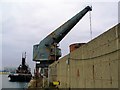
Crane and tug-boat in Aldrington Basin
Image: © tristan forward
Taken: 15 Mar 2005
0.02 miles
2
Steam tug 'Challenge' at aggregate wharf
The preserved tug is undergoing restoration, and recently (September 2012) has been fitted with a new boiler. See http://www.stchallenge.org/
Image: © Robin Webster
Taken: 23 Mar 2010
0.02 miles
3
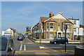
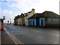
Basin Road North
One way street that connects Wharf Road to this junction with the A259.
Image: © Simon Carey
Taken: 2 Dec 2010
0.02 miles
4
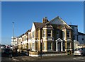
387-399, Kingsway, Aldrington, Hove
Built in the early 1900s and originally called St Leonard's Terrace until the late 1950s. It is located on the corner of St Leonard's Road.
Image: © Simon Carey
Taken: 22 Dec 2016
0.03 miles
5
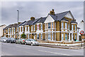
387 - 399 Kingsway
Terrace of early 20th Century houses, first shown on the 1912 25 inch map, where they are marked as St Leonards Terrace.
Image: © Ian Capper
Taken: 21 Jan 2022
0.03 miles
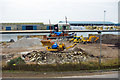
8

Building work on corner block
An overhaul of a rather run-down looking building.
Image: © Robin Webster
Taken: 23 Mar 2010
0.04 miles
9
Ferry Wharf
Part of Shoreham port viewed from Kingsway, the A259. The wharf is named after a small ferry which once carried workers from Porslade across The Canal to gasworks on the far side. The current southern side of the harbour is occupied by port owned warehouses.
Image: © Simon Carey
Taken: 2 Dec 2010
0.04 miles
10
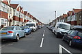
Terraced Houses, Wellington Road
Looking back towards the road's junction with the B2194. The area once consisted of a large number of similar rows of houses as the area built up alongside the wharves and quays of Shoreham Harbour. Most were removed in slum clearences in the 1950s with just the odd row remaining.
Image: © Simon Carey
Taken: 9 Dec 2007
0.04 miles