IMAGES TAKEN NEAR TO
Downland Drive, HOVE, BN3 8GL
Introduction
This page details the photographs taken nearby to Downland Drive, BN3 8GL by members of the Geograph project.
The Geograph project started in 2005 with the aim of publishing, organising and preserving representative images for every square kilometre of Great Britain, Ireland and the Isle of Man.

There are currently over 7.5m images from over14,400 individuals and you can help contribute to the project by visiting https://www.geograph.org.uk
Image Map
Images are licensed for reuse under creativecommons.org/licenses/by-sa/2.0
Notes
- Clicking on the map will re-center to the selected point.
- The higher the marker number, the further away the image location is from the centre of the postcode.
Image Listing (15 Images Found)
Images are licensed for reuse under creativecommons.org/licenses/by-sa/2.0
Image
Details
Distance
1
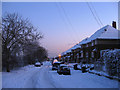
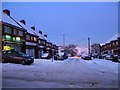
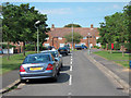
Downland Drive
Part of the Sunninghill estate that was built in the immediate postwar reputedly with assistance of German POWs. The houses look over Toads Hole Valley.
Image: © Simon Carey
Taken: 7 Jan 2010
0.01 miles
3
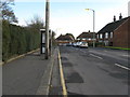
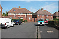
Shops, Burwash Road
Lining the northern side of the street between Poynings Drive and Downland Drive. The second shop on the left is the driving test centre for Hove.
Image: © Simon Carey
Taken: 7 Jan 2010
0.08 miles
5
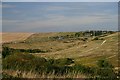
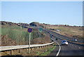
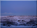
South Downs from the northern edge of Hove
The A27 cuts across the Downs to the north of Hove. In the middle ground are tracks made by motorcycle scramblers.
Image: © Bob Jones
Taken: 9 Aug 2005
0.12 miles
7
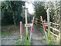
Gateway on The Monarch's Way
With the gate to the left open this interesting device seems of little use.
Image: © Peter Holmes
Taken: 26 Jan 2008
0.14 miles
8
West Blatchington Infant and Junior Schools
Located on the outskirts of Brighton and viewed from the Monarch's Way at dusk.
Image: © Simon Carey
Taken: 7 Jan 2010
0.17 miles
9
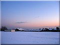
Toads Hole Valley at Dusk
Taken from Downland Drive. The area is owned privately and may well end up becoming a small estate of industrial units some time in the near future. It is bounded by the A27 Brighton by-pass on the left whose junction with Dyke Road can be made out by the street lights and King George VI Avenue, the A2038, to the right. Both converge at Red Hill in the centre.
Image: © Simon Carey
Taken: 7 Jan 2010
0.17 miles