IMAGES TAKEN NEAR TO
Hangleton Valley Drive, HOVE, BN3 8FE
Introduction
This page details the photographs taken nearby to Hangleton Valley Drive, BN3 8FE by members of the Geograph project.
The Geograph project started in 2005 with the aim of publishing, organising and preserving representative images for every square kilometre of Great Britain, Ireland and the Isle of Man.

There are currently over 7.5m images from over14,400 individuals and you can help contribute to the project by visiting https://www.geograph.org.uk
Image Map (Loading...)


Getting Data...Please wait
Leaflet Map data © OpenStreetMap
Images are licensed for reuse under creativecommons.org/licenses/by-sa/2.0
Notes
- Clicking on the map will re-center to the selected point.
- The higher the marker number, the further away the image location is from the centre of the postcode.
Image Listing (50 Images Found)
Images are licensed for reuse under creativecommons.org/licenses/by-sa/2.0
Image
Details
Distance
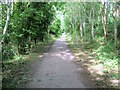
2
Dyke Railway Trail, Hangleton
The Dyke Railway Trail is a path following the course of a dismantled railway.
A summary of the trail is available on the South Downs National Park website: http://www.southdowns.gov.uk/__data/assets/pdf_file/0008/123002/Dyke-Railway.pdf
Image: © Malc McDonald
Taken: 9 Dec 2012
0.12 miles
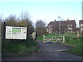
3
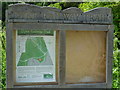
Notice at the southern end of the Dyke Railway Trail
The notice refers to the "cyclists' and country codes" but they are not shown and should probably be in the empty half of the display.
Image: © Shazz
Taken: 27 Jun 2011
0.12 miles
4
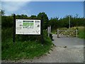
The southern end of the Dyke Railway Trail
This trail is on the course of the railway that ran between Aldrington and Devil's Dyke. The line opened in 1887 and closed in 1938.
Image: © Shazz
Taken: 27 Jun 2011
0.12 miles
5
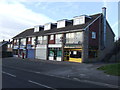
Parade of shops, Hangleton
A parade of local shops with flats above them, in Hangleton.
Image: © Malc McDonald
Taken: 9 Dec 2012
0.12 miles
6
The A27(T) west of the Dyke Railway Trail bridge
Image: © Shazz
Taken: 27 Jun 2011
0.13 miles
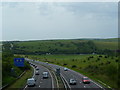
7
Brighton By-Pass
The A27 viewed from the footbridge that carries the Dyke Railway Trail. Taken at sunset with Benfield Hill in the distance and the road relatively empty due to the weather.
Image: © Simon Carey
Taken: 7 Jan 2010
0.13 miles
9
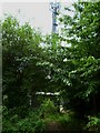
Mast by the Dyke Railway Trail
Another view of the mast is at http://www.geograph.org.uk/photo/1449556
Image: © Shazz
Taken: 27 Jun 2011
0.14 miles
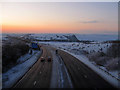
10
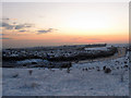
Brighton By-Pass
Constructed in the early 1990s to take the busy A27 away from the congested roads of the Brighton and Hove conurbation. Beyond the by-pass is the suburb of Hangleton and in the distance is the chimney of Shoreham power station. Taken at sunset with the last sun of the day just visible before it disappears near Foredown Tower to the right.
Image: © Simon Carey
Taken: 7 Jan 2010
0.14 miles