IMAGES TAKEN NEAR TO
Egmont Road, HOVE, BN3 7FN
Introduction
This page details the photographs taken nearby to Egmont Road, BN3 7FN by members of the Geograph project.
The Geograph project started in 2005 with the aim of publishing, organising and preserving representative images for every square kilometre of Great Britain, Ireland and the Isle of Man.

There are currently over 7.5m images from over14,400 individuals and you can help contribute to the project by visiting https://www.geograph.org.uk
Image Map
Images are licensed for reuse under creativecommons.org/licenses/by-sa/2.0
Notes
- Clicking on the map will re-center to the selected point.
- The higher the marker number, the further away the image location is from the centre of the postcode.
Image Listing (48 Images Found)
Images are licensed for reuse under creativecommons.org/licenses/by-sa/2.0
Image
Details
Distance
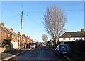
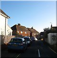
1
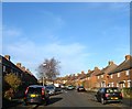
Egmont Road, Knoll Estate, Hove
A residential road linking Bellingham Crescent to Martin Road that was built in the late 1920s.
The Knoll Estate is located in the former northern portion of the parish of Aldrington which was once three open fields called The Knowle East, The Knowle West and The Knowle North according to its 1840 tithe map. The area was developed by Hove council from 1926 and mostly completed by 1939, the remaining undeveloped part at the northern end of Stapley Road was finished in the late 1940s.
Image: © Simon Carey
Taken: 22 Dec 2016
0.02 miles
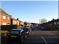
2
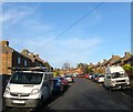
Wilfrid Road, Knoll Estate, Hove
A residential road linking Bellingham Crescent to Martin Road that was built in the late 1920s.
The Knoll Estate is located in the former northern portion of the parish of Aldrington which was once three open fields called The Knowle East, The Knowle West and The Knowle North according to its 1840 tithe map. The area was developed by Hove council from 1926 and mostly completed by 1939, the remaining undeveloped part at the northern end of Stapley Road was finished in the late 1940s.
Image: © Simon Carey
Taken: 22 Dec 2016
0.05 miles
3
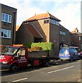
St Richard's Church, Egmont Road, Knoll Estate, Hove
Church and community centre built in the 1930s near the junction with Bellingham Crescent.
The Knoll Estate is located in the former northern portion of the parish of Aldrington which was once three open fields called The Knowle East, The Knowle West and The Knowle North according to its 1840 tithe map. The area was developed by Hove council from 1926 and mostly completed by 1939, the remaining undeveloped part at the northern end of Stapley Road was finished in the late 1940s.
Image: © Simon Carey
Taken: 22 Dec 2016
0.07 miles
4
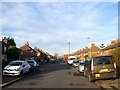
Stapley Road, Knoll Estate, Hove
A residential road that links Old Shoreham Road, the A270, to Hangleton Road, the A2038. The road was developed as far as Martin Road in the 1920s with the remaining section north to Hangleton Road completed in the late 1940s.
The Knoll Estate is located in the former northern portion of the parish of Aldrington which was once three open fields called The Knowle East, The Knowle West and The Knowle North according to its 1840 tithe map. The area was developed by Hove council from 1926 and mostly completed by 1939, the remaining undeveloped part at the northern end of Stapley Road was finished in the late 1940s.
Image: © Simon Carey
Taken: 22 Dec 2016
0.08 miles
5
Martin Road, Knoll Estate, Hove
A residential road that links Hangleton Road, the A2038, with Stapley Road that was laid out in the 1920s, but not developed until the 1940s.
The Knoll Estate is located in the former northern portion of the parish of Aldrington which was once three open fields called The Knowle East, The Knowle West and The Knowle North according to its 1840 tithe map. The area was developed by Hove council from 1926 and mostly completed by 1939, the remaining undeveloped part at the northern end of Stapley Road was finished in the late 1940s.
Image: © Simon Carey
Taken: 22 Dec 2016
0.08 miles
6
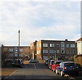
St Richard's Court, Bellingham Crescent, Knoll Estate, Hove
A block of flats built in the 1960s at the junction with Egmont Road and located to the immediate south of Image
The Knoll Estate is located in the former northern portion of the parish of Aldrington which was once three open fields called The Knowle East, The Knowle West and The Knowle North according to its 1840 tithe map. The area was developed by Hove council from 1926 and mostly completed by 1939, the remaining undeveloped part at the northern end of Stapley Road was finished in the late 1940s.
Image: © Simon Carey
Taken: 22 Dec 2016
0.10 miles
7
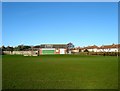
Knoll Recreation Ground, Hove
Built in the 1950s on Hudson's Tip, a former rubbish dump. Access is via footpath from Stapley Road and Rowan Avenue to the north and another that follows the former trackbed of the Dyke Railway from Hove Cemetery to the south. The park includes two junior football pitches, a green belonging to Hangleton Bowls Club immediately beyond the pavilion in view, an enclosed basketball court and a children's playground. The houses on the right face onto Rowan Avenue and were constructed in the 1930s.
Image: © Simon Carey
Taken: 5 Jan 2017
0.12 miles
8
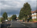
Houses on Hangleton Road
Hangleton Way to left after pedestrian crossing.
Image: © Oast House Archive
Taken: 16 Oct 2010
0.12 miles
9
Knoll Close, Knoll Estate, Hove
A cul de sac off Godwin Road that was built in 1948.
The Knoll Estate is located in the former northern portion of the parish of Aldrington which was once three open fields called The Knowle East, The Knowle West and The Knowle North according to its 1840 tithe map. The area was developed by Hove council from 1926 and mostly completed by 1939, the remaining undeveloped part at the northern end of Stapley Road was finished in the late 1940s.
Image: © Simon Carey
Taken: 22 Dec 2016
0.13 miles
10
Bellingham Crescent, Knoll Estate, Hove
A resindential road that originally linked Stapley Road to Old Shoreham Road, the former A27, though the latter was blocked when the road was widened in the 1970s. The road was developed in the 1920s.
The Knoll Estate is located in the former northern portion of the parish of Aldrington which was once three open fields called The Knowle East, The Knowle West and The Knowle North according to its 1840 tithe map. The area was developed by Hove council from 1926 and mostly completed by 1939, the remaining undeveloped part at the northern end of Stapley Road was finished in the late 1940s.
Image: © Simon Carey
Taken: 22 Dec 2016
0.14 miles