IMAGES TAKEN NEAR TO
St. Josephs Close, HOVE, BN3 7ES
Introduction
This page details the photographs taken nearby to St. Josephs Close, BN3 7ES by members of the Geograph project.
The Geograph project started in 2005 with the aim of publishing, organising and preserving representative images for every square kilometre of Great Britain, Ireland and the Isle of Man.

There are currently over 7.5m images from over14,400 individuals and you can help contribute to the project by visiting https://www.geograph.org.uk
Image Map (Loading...)


Getting Data...Please wait
Leaflet Map data © OpenStreetMap
Images are licensed for reuse under creativecommons.org/licenses/by-sa/2.0
Notes
- Clicking on the map will re-center to the selected point.
- The higher the marker number, the further away the image location is from the centre of the postcode.
Image Listing (110 Images Found)
Images are licensed for reuse under creativecommons.org/licenses/by-sa/2.0
Image
Details
Distance
1
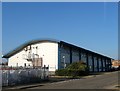
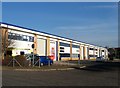
Hove Technology Centre, St Joseph's Close, Hove
Built in the late 1990s on the site of a former ambulance station which moved to new premises at number 2. As the name suggests it houses a number of small technology firms.
Image: © Simon Carey
Taken: 22 Jan 2017
0.02 miles
2
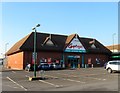
15, St Joseph's Close, Hove
Currently occupied by SIG Roofing suppliers. The building beyond is part of Hosiden Besson, see Image Both structures date from the 1950s and were most likely one establishment at one time.
Image: © Simon Carey
Taken: 22 Jan 2017
0.02 miles
3
8, St Joseph's Close, Hove
Small business unit built in the 1950s that is currently empty. Number 10 is to the rear of the building and suggests that the pair were once a single establishment.
Image: © Simon Carey
Taken: 22 Jan 2017
0.02 miles
4
12, St Joseph's Close, Hove
Currently home to Hosiden Besson Ltd who manufacture sound and listening equipment. The firm also occupies Image The building dates from the 1950s.
Image: © Simon Carey
Taken: 22 Jan 2017
0.03 miles
5
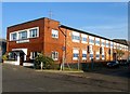
1-7, St Joseph's Business Park, St Joseph's Close, Hove
Occupying part of the grounds of a former council depot and built around 2001.
Image: © Simon Carey
Taken: 22 Jan 2017
0.04 miles
6

Council Incinerator, St Joseph's Trading Estate
Viewed from the western end of Aldrington station.
Image: © Simon Carey
Taken: 14 Jan 2009
0.05 miles
7
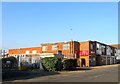
6, St Joseph's Close, Hove
Currently home to Carpet Right the unit was built in the mid 1980s on the site of the extensive gardens of St Joseph's Home, See Image, which is located to the immediate north.
Image: © Simon Carey
Taken: 22 Jan 2017
0.06 miles
8
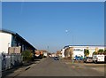
St Joseph's Close, Hove
Cul de sac off Old Shoreham Road that is primarily a business estate. The southern portion abutting the railway was originally part of an electricity works that became a council refuse destructor works in 1931. The destructor closed in the early 1970s though the council continued using it as a depot until the late 1990s after which this section was sold and turned into business units. The road itself is named after a former convent and nursing home whose site is now occupied by Image and Image and, although originally the access road to the depot, began to be developed around the 1950s. To the right is Image whilst on the left is Image
Image: © Simon Carey
Taken: 22 Jan 2017
0.07 miles
9

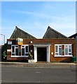
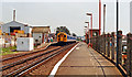
Aldrington Station
Opened in 1905 as Dyke Junction Halt to serve as an interchange for the Dyke branch railway. It was renamed Aldrington Halt in 1932 and eventually became just Aldrington. Staffing went in 1990 and a couple of small shelters are the only facilities available here though it is served by 4 trains in each direction per hour during the day and can be busy in peak periods. The buildings from St Joseph's trading estate are on the left.
Image: © Simon Carey
Taken: 14 Jan 2009
0.08 miles
10
Aldrington station, 1990
View eastward, towards Hove and Brighton: ex-LB&SCR Brighton - Littlehampton/Portsmouth main line. The station was 'Dyke Junction' until 6/32, Aldrington 'Halt' until 5/69.
Image: © Ben Brooksbank
Taken: 12 Jul 1990
0.08 miles