IMAGES TAKEN NEAR TO
Old Shoreham Road, HOVE, BN3 7EF
Introduction
This page details the photographs taken nearby to Old Shoreham Road, BN3 7EF by members of the Geograph project.
The Geograph project started in 2005 with the aim of publishing, organising and preserving representative images for every square kilometre of Great Britain, Ireland and the Isle of Man.

There are currently over 7.5m images from over14,400 individuals and you can help contribute to the project by visiting https://www.geograph.org.uk
Image Map
Images are licensed for reuse under creativecommons.org/licenses/by-sa/2.0
Notes
- Clicking on the map will re-center to the selected point.
- The higher the marker number, the further away the image location is from the centre of the postcode.
Image Listing (104 Images Found)
Images are licensed for reuse under creativecommons.org/licenses/by-sa/2.0
Image
Details
Distance
1
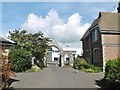
Hove, gateway
At the entrance to Hove Cemetery (South), on Old Shoreham Road.
Image: © Mike Faherty
Taken: 15 Sep 2018
0.01 miles
2
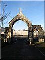
Entrance to Hove Cemetery
The cemetery was opened in 1882 and covers 50 acres straddling the Old Shoreham Road which can be seen through this arch.
Image: © Simon Carey
Taken: 14 Jan 2009
0.01 miles
3
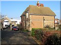
Cemetery Lodge, Hove Cemetery
Viewed from the southern side and erected in 1882.
Hove Cemetery consists of two parts, the original section south of Old Shoreham Road that was first consecrated in 1882 and a second to the north of the road that opened in 1923 as an extension
Image: © Simon Carey
Taken: 22 Jan 2017
0.01 miles
4
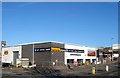
Delphi House, Old Shoreham Road, Hove
Built around 1963 on the site of the former Sackville Nurseries and currently occupied by a Halfords garage and tool hire company. Originally a warehouse the building appears to have been rebuilt at some time, see http://regencysociety-jamesgray.com/volume16/source/jg_16_143.html from 1969.
Image: © Simon Carey
Taken: 5 Jan 2017
0.02 miles
5
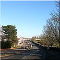
Old Shoreham Road, Hove
A view of the road as it drops into what was once known as Hangleton Bottom with Hove cemetery's southern portion to the right. To the left are a series of commercial premises built on the site of the former Sackville Nurseries. At the top of the further slope is the site of a former bridge that spanned the Dyke Railway that operated between 1887 to 1938. See http://regencysociety-jamesgray.com/volume16/source/jg_16_141.html for a similar view taken in 1969 a few years before the road became a dual carriageway.
Image: © Simon Carey
Taken: 5 Jan 2017
0.03 miles
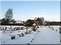
6

First World War Memorial, Hove Cemetery
Located beneath the access road connecting Image to Image and erected in 1921. A memorial dedicated to the fallen of World War Two is located in the northern section.
Hove Cemetery consists of two parts, the original section south of Old Shoreham Road that was first consecrated in 1882 and a second to the north of the road that opened in 1923 as an extension.
Image: © Simon Carey
Taken: 22 Jan 2017
0.03 miles
8
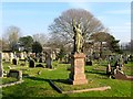
James Armstrong Welch's Grave, Hove Cemetery
Born in Philadelphia, USA, died in Nice, France probably in 1931 though the second digit of four has fallen off. Located in the southern section of the cemetery that opened in 1882 not far from the entrance lodge.
Hove Cemetery consists of two parts, the original section south of Old Shoreham Road that was first consecrated in 1882 and a second to the north of the road that opened in 1923 as an extension.
Image: © Simon Carey
Taken: 22 Jan 2017
0.03 miles
9

271, Old Shoreham Road, Hove
Currently occupied by wine warehouse, Majestic Wines. If you think the exterior looks suspiciously like a filling station then that is because it once was, see http://regencysociety-jamesgray.com/volume16/source/jg_16_143.html for a view taken in 1969.
Image: © Simon Carey
Taken: 5 Jan 2017
0.04 miles
10
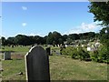
Hove Cemetery in the Snow
Opened in 1882 and covering 50 acres either side of the Old Shoreham Road. This looks back towards the entrance lodge on the A270.
Image: © Simon Carey
Taken: 7 Jan 2010
0.04 miles