IMAGES TAKEN NEAR TO
Orchard Road, HOVE, BN3 7BG
Introduction
This page details the photographs taken nearby to Orchard Road, BN3 7BG by members of the Geograph project.
The Geograph project started in 2005 with the aim of publishing, organising and preserving representative images for every square kilometre of Great Britain, Ireland and the Isle of Man.

There are currently over 7.5m images from over14,400 individuals and you can help contribute to the project by visiting https://www.geograph.org.uk
Image Map
Images are licensed for reuse under creativecommons.org/licenses/by-sa/2.0
Notes
- Clicking on the map will re-center to the selected point.
- The higher the marker number, the further away the image location is from the centre of the postcode.
Image Listing (142 Images Found)
Images are licensed for reuse under creativecommons.org/licenses/by-sa/2.0
Image
Details
Distance
1
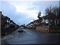
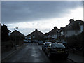
Orchard Gardens
Linking Orchard Road with Nevill Road, the small estate was built in the 1920s on the site of a former apple orchard some of whose trees survived in the back gardens of the newly built houses.
Image: © Simon Carey
Taken: 18 Jan 2009
0.04 miles
2
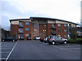
March House
New development built on the former Alliance and Leicester site which itself was built in 1967 before the company moved to Leicester in 1993 and sold the site for development. At one point the site was suggested as the place to build the new football ground for Brighton & Hove Albion but by the time of the government enquiry plans had already been drawn up to build new offices and homes which were opened in the last couple of years. March House faces out onto Orchard Road along with Orchard House next door, the rest of the site is taken up by new offices for Legal & General.
Image: © Simon Carey
Taken: 18 Jan 2009
0.05 miles
3
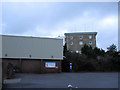
Corals Health and Leisure Centre
Looking towards the entrance from the car park. The leisure centre was built in south western grounds of the Brighton & Hove Stadium greyhound track whom Corals have owned since 1976. The rear of the old tote building is on the right, it was converted to track offices in 1993.
Image: © Simon Carey
Taken: 18 Jan 2009
0.06 miles
4
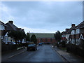
Orchard Avenue
Linking Orchard Road with Orchard Gardens, the small estate was built in the 1920s on the site of a former apple orchard some of whose trees survived in the back gardens of the newly built houses. The works on Orchard Gardens are the rear of Dugard Precision Engineering who front out onto Old Shoreham Road. The Dugard family have had a long association with Eastbourne Eagles speedway team.
Image: © Simon Carey
Taken: 18 Jan 2009
0.07 miles
5
Orchard Gardens
Linking Orchard Road with Nevill Road, the small estate was built in the 1920s on the site of a former apple orchard some of whose trees survived in the back gardens of the newly built houses.
Image: © Simon Carey
Taken: 18 Jan 2009
0.08 miles
6
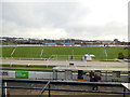
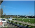
Coral Greyhound Stadium, Hove
Viewed from the cafe
Image: © Paul Gillett
Taken: 24 Nov 2013
0.08 miles
7
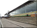
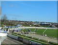
Terracing at Greyhound Stadium
Looking towards the windows of the café and restaurant where punters can enjoy a meal whilst watching the races
Image: © Paul Gillett
Taken: 24 Nov 2013
0.09 miles
8
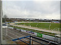
Coral Greyhound Stadium, Hove
Looking NE from the cafe
Image: © Paul Gillett
Taken: 24 Nov 2013
0.09 miles
10
Leaving the traps
The dogs are on their way in the 11.43 race at the Coral Greyhound Stadium
Image: © Paul Gillett
Taken: 24 Nov 2013
0.09 miles