IMAGES TAKEN NEAR TO
Old Shoreham Road, HOVE, BN3 7AQ
Introduction
This page details the photographs taken nearby to Old Shoreham Road, BN3 7AQ by members of the Geograph project.
The Geograph project started in 2005 with the aim of publishing, organising and preserving representative images for every square kilometre of Great Britain, Ireland and the Isle of Man.

There are currently over 7.5m images from over14,400 individuals and you can help contribute to the project by visiting https://www.geograph.org.uk
Image Map
Images are licensed for reuse under creativecommons.org/licenses/by-sa/2.0
Notes
- Clicking on the map will re-center to the selected point.
- The higher the marker number, the further away the image location is from the centre of the postcode.
Image Listing (79 Images Found)
Images are licensed for reuse under creativecommons.org/licenses/by-sa/2.0
Image
Details
Distance
1
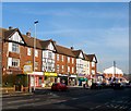
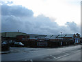
87-101, Old Shoreham Road, Hove
A parade of shops on the western side of the junction with Neveill Road, the A2023, that were built in the mid 1930s. Currently occupied by a shed retailer, funeral directors, newsagent, pizza delivery chain, barbers, electrical retailer, tanning salon and a sandwich shop.
Image: © Simon Carey
Taken: 22 Jan 2017
0.02 miles
2
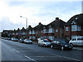
Nevill Road
The housing between Old Shoreham Road and the entrance to Hove Park School. Nevill Road was originally a farm track that linked Old Shoreham Road with The Droveway within the parish of West Blatchington. It was taken over by Hove corporation in 1928 and begun to be developed in the 1930s and originally extended up to the junction with Dyke Road but now stops at the junction with the A2038.
Image: © Simon Carey
Taken: 18 Jan 2009
0.04 miles
5
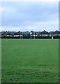
Playing Field, Hove Park School
Built on the site of former allotments in the 1930s when the originally Hove County Grammar School for Girls. The current mixed comprehensive originates from 1979 when a number of schools were reorganised in the area. The houses beyond the rugby posts are the rear of those in Nevill Road.
Image: © Simon Carey
Taken: 18 Jan 2009
0.06 miles
6
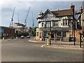
85, Old Shoreham Road, Hove
Located on the corner of Nevill Road at a rather busy road junction. Currently occupied by Kwik Fit though the building dates back to the 1920s.
Image: © Simon Carey
Taken: 5 Jan 2017
0.06 miles
7
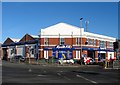
182, Old Shoreham Road, Hove
Currently home to Homebase, the DIY chain. The building was erected in the 1980s on the site of the former St Joseph's Home, a nursing home run by the Roman Catholic Little Sisters of the Poor. The home was constructed around 1884 and had a chapel added in 1900. It closed in 1980 and all the buildings were demolished in 1983/84.
Image: © Simon Carey
Taken: 22 Jan 2017
0.07 miles
8
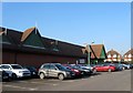
Portslade Pannelworks
Located on the corner of Nevill Road and Orchard Gardens the works have been here since 1990. It seems this part of Brighton and Hove has just managed to miss the rain this morning.
Image: © Simon Carey
Taken: 18 Jan 2009
0.07 miles
10
Hove Ambulance Station
On Old Shoreham Road, at the corner of St. Joseph's Close: http://www.secamb.nhs.uk/about_us/our_locations.aspx
Image: © Mike Faherty
Taken: 15 Sep 2018
0.08 miles