IMAGES TAKEN NEAR TO
Hove Park Way, HOVE, BN3 6PS
Introduction
This page details the photographs taken nearby to Hove Park Way, BN3 6PS by members of the Geograph project.
The Geograph project started in 2005 with the aim of publishing, organising and preserving representative images for every square kilometre of Great Britain, Ireland and the Isle of Man.

There are currently over 7.5m images from over14,400 individuals and you can help contribute to the project by visiting https://www.geograph.org.uk
Image Map
Images are licensed for reuse under creativecommons.org/licenses/by-sa/2.0
Notes
- Clicking on the map will re-center to the selected point.
- The higher the marker number, the further away the image location is from the centre of the postcode.
Image Listing (105 Images Found)
Images are licensed for reuse under creativecommons.org/licenses/by-sa/2.0
Image
Details
Distance
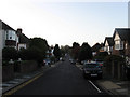
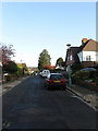
1
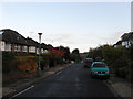
Hove Park Way
Residential street linking Hove Park Road to Woodruff Avenue. Autumn colours and mock Tudor in plentiful evidence.
Image: © Simon Carey
Taken: 25 Oct 2009
0.02 miles
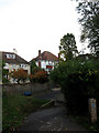
2
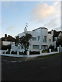
Casablanca, The Droveway
Art deco house built in the 1930s on what as and still is to a certain extent an expensive and exclusive part of Hove. Located on the junction of The Droveway and Hove Park Way.
Image: © Simon Carey
Taken: 25 Oct 2009
0.06 miles
3
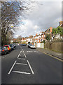
Goldstone Crescent
The section between Hove Park Road and The Droveway. The road links Old Shoreham Road, the A270, with King George VI Avenue, the A2038 following the eastern then base of the dry valley formerly known as Goldstone Bottom.
Image: © Simon Carey
Taken: 18 Jan 2009
0.06 miles
4
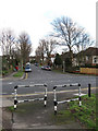
The Droveway
Ancient east-west route that once followed the Downs and through small villages such as Preston and West Blatchington. Part of it is now built up but ancient rights of way laws meant it could not be removed when Hove Park was laid out in 1905. Goldstone Crescent crosses from left to right.
Image: © Simon Carey
Taken: 18 Jan 2009
0.07 miles
5
Hove Park Way
Residential street linking Hove Park Road to Woodruff Avenue. This section looks down towards the crossroads with The Droveway.
Image: © Simon Carey
Taken: 25 Oct 2009
0.08 miles
6
Exiting Hove Recreation Ground
The north west exit is also part of national cycle route 28. The houses are in Hove Park Road.
Image: © Simon Carey
Taken: 25 Oct 2009
0.08 miles
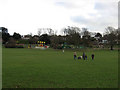
7
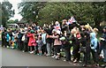
Awaiting the Olympic Torch in Hove Park
In spite of the damp conditions the crowd remains in good spirits awaiting a glimpse of the flame Image] as it makes its way to the Cricket ground for the main celebration of the day.
Image: © Paul Gillett
Taken: 16 Jul 2012
0.09 miles
8
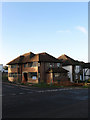
New House, Bishops Road
On the crossroads of that road and The Droveway. Not quite sure if it is new or is being rebuilt or extended.
Image: © Simon Carey
Taken: 25 Oct 2009
0.10 miles
9
Bishops Road
Residential road linking Hove Park Road with Woodruff Avenue. Developed from the late 1920s onwards.
Image: © Simon Carey
Taken: 25 Oct 2009
0.10 miles
10
Play Area, Hove Park
On the eastern side of the park and being well used today.
Image: © Simon Carey
Taken: 18 Jan 2009
0.10 miles