IMAGES TAKEN NEAR TO
Woodruff Avenue, HOVE, BN3 6PF
Introduction
This page details the photographs taken nearby to Woodruff Avenue, BN3 6PF by members of the Geograph project.
The Geograph project started in 2005 with the aim of publishing, organising and preserving representative images for every square kilometre of Great Britain, Ireland and the Isle of Man.

There are currently over 7.5m images from over14,400 individuals and you can help contribute to the project by visiting https://www.geograph.org.uk
Image Map
Images are licensed for reuse under creativecommons.org/licenses/by-sa/2.0
Notes
- Clicking on the map will re-center to the selected point.
- The higher the marker number, the further away the image location is from the centre of the postcode.
Image Listing (67 Images Found)
Images are licensed for reuse under creativecommons.org/licenses/by-sa/2.0
Image
Details
Distance
1
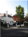
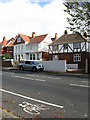
Houses, Woodruff Avenue
The collapse of the housing market obviously hasn't affected the selling of the white house.
Image: © Simon Carey
Taken: 25 Oct 2009
0.03 miles
2
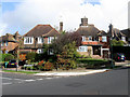
Houses on the Corner
On the north east side of the Woodruff Avenue-Tongdean Avenue junction with fine views down to the sea.
Image: © Simon Carey
Taken: 25 Oct 2009
0.04 miles
3
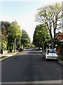
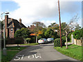
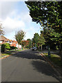
Woodruff Avenue
Residential road linking Goldstone Crescent to Dyke Road. This section lies between the junctions with Tongdean Avenue and Mallory Road and the latter. The road is a bit of a rat run between Shirley Drive and Dyke Road for those travelling into or out of town. I'll hold my hand up here as it is my favoured route between the two.
Image: © Simon Carey
Taken: 25 Oct 2009
0.05 miles
4
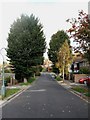
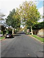
Mallory Road
Looking towards the northern junction with Woodruff Avenue.
Image: © Simon Carey
Taken: 25 Oct 2009
0.06 miles
5
Barrowfield Drive
Small upmarket estate built around Barrowfield Lodge during the 1930s.
Image: © Simon Carey
Taken: 25 Oct 2009
0.08 miles
6
Tongdean Avenue
Residential road linking Woodruff Avenue with Tongdean Road. One of the most upmarket and exclusive roads in Hove which also happens to filled with learner drivers practising their manoeuvres during the day due to its quiet and wide nature.
Image: © Simon Carey
Taken: 25 Oct 2009
0.08 miles
7
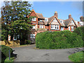
Barrowfield Lodge
Late Victorian large house that has now been converted into flats. The surrounding grounds were sold in 1931 and turned into the Barrowfield estate.
Image: © Simon Carey
Taken: 25 Oct 2009
0.09 miles
9
Mallory Road
Residential road that begins at Woodruff Avenue in the north and finishes as a dead end behind the Dairy Crest dairy to the south. This section lies between the former and the crossroads with Onslow Road.
Image: © Simon Carey
Taken: 25 Oct 2009
0.10 miles
10
Houses, Dyke Road
On the Brighton side of the road where many of the residences were developed in the first decade of the twentieth century.
Image: © Simon Carey
Taken: 25 Oct 2009
0.10 miles