IMAGES TAKEN NEAR TO
Radinden Drive, HOVE, BN3 6LB
Introduction
This page details the photographs taken nearby to Radinden Drive, BN3 6LB by members of the Geograph project.
The Geograph project started in 2005 with the aim of publishing, organising and preserving representative images for every square kilometre of Great Britain, Ireland and the Isle of Man.

There are currently over 7.5m images from over14,400 individuals and you can help contribute to the project by visiting https://www.geograph.org.uk
Image Map
Images are licensed for reuse under creativecommons.org/licenses/by-sa/2.0
Notes
- Clicking on the map will re-center to the selected point.
- The higher the marker number, the further away the image location is from the centre of the postcode.
Image Listing (86 Images Found)
Images are licensed for reuse under creativecommons.org/licenses/by-sa/2.0
Image
Details
Distance
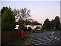
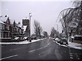
1
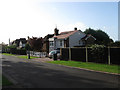
Radinden Drive
Small cul-de-sac off Hove Park Road.
Image: © Simon Carey
Taken: 25 Oct 2009
0.02 miles
2
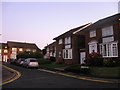
Fulmar Close
Small cul-de-sac off The Martlets built in the 1960s on the site of an old school.
Image: © Simon Carey
Taken: 25 Oct 2009
0.04 miles
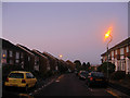
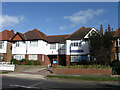
3
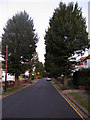
Orpen Road
Residential road linking Radinden Manor Road with Hove Park Road. Developed from 1928 onwards when parts of the former Preston rural district were transferred to Hove. Taken just before sunrise.
Image: © Simon Carey
Taken: 25 Oct 2009
0.06 miles
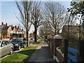
4
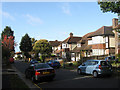
Hove Park Road
Residential road that links Dyke Road with Goldstone Crescent. This is the section between the former and the junctions with Orpen Road and Lloyd Road.
Image: © Simon Carey
Taken: 25 Oct 2009
0.06 miles
5
Postbox, Hove Park Road
At the junction of Hove Park Road, Orpen Road and Lloyd Road.
Image: © Simon Carey
Taken: 25 Oct 2009
0.08 miles
6
The Martlets
Housing estate built in the 1960s on the site of an old school. Taken about 15 minutes before sunrise.
Image: © Simon Carey
Taken: 25 Oct 2009
0.09 miles
8
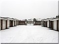
Entrance to Covered Reservoir
Looking past a set of garages towards the flint wall that surrounds the reservoir which was created in the last decades of the 19th century and predates all except Cardinal Newman School on the section of The Upper Drive between Old Shoreham Road and Dyke Road.
Image: © Simon Carey
Taken: 20 Jan 2013
0.10 miles
9
Dyke Road
One of the main arterial roads in and out of the city that starts at North Street in the centre of town then becomes Dyke Road Avenue before heading off to a junction with the A27. For many years the old boundary between Brighton and Hove ran down the western side of the road. Viewed from the junction with The Droveway and taken at dusk.
Image: © Simon Carey
Taken: 20 Jan 2013
0.11 miles
10
Dyke Road Dentist
Recently opened dental practice who are currently advertising for NHS patients.
Image: © Simon Carey
Taken: 25 Oct 2009
0.11 miles