IMAGES TAKEN NEAR TO
Ranelagh Villas, HOVE, BN3 6HE
Introduction
This page details the photographs taken nearby to Ranelagh Villas, BN3 6HE by members of the Geograph project.
The Geograph project started in 2005 with the aim of publishing, organising and preserving representative images for every square kilometre of Great Britain, Ireland and the Isle of Man.

There are currently over 7.5m images from over14,400 individuals and you can help contribute to the project by visiting https://www.geograph.org.uk
Image Map
Images are licensed for reuse under creativecommons.org/licenses/by-sa/2.0
Notes
- Clicking on the map will re-center to the selected point.
- The higher the marker number, the further away the image location is from the centre of the postcode.
Image Listing (174 Images Found)
Images are licensed for reuse under creativecommons.org/licenses/by-sa/2.0
Image
Details
Distance
1
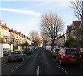
Ranelagh Villas, Hove
A residential road linking Fonthill Road to Hove Park Villas that was built in the 1890s.
Image: © Simon Carey
Taken: 22 Jan 2017
0.03 miles
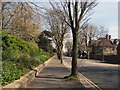
2
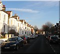
Hartington Villas, Hove
A residential road that links Fonthill Road to Hove Park Villas that was constructed in the 1890s.
Image: © Simon Carey
Taken: 22 Jan 2017
0.06 miles
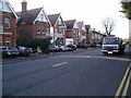
3
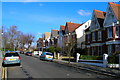
Hove Park Villas
This part of Hove was laid out in the early part of the twentieth century and are still desirable city townhouses now. This view looks north north east from the western edge of the grid square towards the junction with the A27 Old Shoreham Road. The trees in the background form the border of Hove Recreation Ground.
Image: © Simon Carey
Taken: 25 Feb 2006
0.07 miles
4
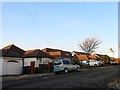
36-48, Fonthill Road, Hove
Semi-detached bungalows (except for 36 on the left) that were built in the mid 1950s on the site of Goldstone House. See http://regencysociety-jamesgray.com/volume16/source/jg_16_074.html for a view taken in 1880 not long after it was built. The house belonged to a local Alderman, JJ Clark, who was instrumental in setting up a local bakery firm, Clark's and also Brighton & Hove Albion, where he leased a field in front of his house that later became the Goldstone Ground. The house was demolished in 1955, see http://regencysociety-jamesgray.com/volume16/source/jg_16_075.html for a view in the same year.
Image: © Simon Carey
Taken: 22 Jan 2017
0.07 miles
5
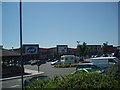
Goldstone Retail Park
Built on the former Goldstone Ground, much loved home of Brighton and Hove Albion from 1902 to 1997
Image: © Paul Gillett
Taken: 16 Jun 2009
0.07 miles
6
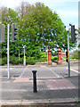
Pedestrian Crossing, Old Shoreham Road
Taken from Hove Park Villas and looking towards the entrance of Hove Park. Old Shoreham Road is the A270.
Image: © Simon Carey
Taken: 4 Jun 2006
0.08 miles
7
The Monarch's Way joins A270 Old Shoreham Road
No more country paths,the remainder of the route through Hove & Brighton to the seafront follows congested roads.
Image: © Peter Holmes
Taken: 26 Jan 2008
0.08 miles
8
Park House, Old Shoreham Road, Hove
Viewed at sunset.
Image: © Simon Carey
Taken: 15 Apr 2020
0.09 miles
9
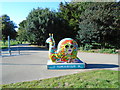
Snailspace #05 Hove Park
Title: Persephone
Artist: Manic Minotaur
Sponsor: Legal and General Assurance Society Ltd
Image: © Paul Gillett
Taken: 27 Sep 2018
0.09 miles
10
Old Shoreham Road
South of Hove recreation ground
Image: © Paul Gillett
Taken: 6 Apr 2012
0.09 miles