IMAGES TAKEN NEAR TO
Caisters Close, HOVE, BN3 6GQ
Introduction
This page details the photographs taken nearby to Caisters Close, BN3 6GQ by members of the Geograph project.
The Geograph project started in 2005 with the aim of publishing, organising and preserving representative images for every square kilometre of Great Britain, Ireland and the Isle of Man.

There are currently over 7.5m images from over14,400 individuals and you can help contribute to the project by visiting https://www.geograph.org.uk
Image Map
Images are licensed for reuse under creativecommons.org/licenses/by-sa/2.0
Notes
- Clicking on the map will re-center to the selected point.
- The higher the marker number, the further away the image location is from the centre of the postcode.
Image Listing (142 Images Found)
Images are licensed for reuse under creativecommons.org/licenses/by-sa/2.0
Image
Details
Distance
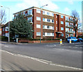
1
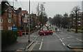
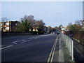
Old Shoreham Road
The A270 Brighton-Shoreham road. It is believed that most of the A270, itself the former A27, was built on the course of an old local Roman road. This stretch lies between Radinden Manor Road and The Drive.
Image: © Simon Carey
Taken: 2 Jul 2006
0.01 miles
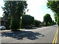
2
Caisters Close
Built on the site of a nursery, from which it takes its name, in the late 1950s. The houses are to the left after the bend at the bottom of the slope.
Image: © Simon Carey
Taken: 2 Jul 2006
0.05 miles
3
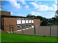
St Mary's Primary School
Taken from the gates on Radinden Manor Road.
Image: © Simon Carey
Taken: 8 Oct 2006
0.06 miles
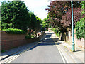
4
The Monarch's Way on The Drive
On the railway bridge over the West Coastway line looking back along the route towards the Old Shoreham Road.
Image: © Peter Holmes
Taken: 26 Jan 2008
0.06 miles
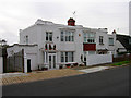
5
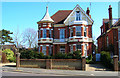
112 The Drive
First of three houses all built in a similar style with the tower and weather vane all on the corner of a junction with Old Shoreham Road and all facing West. This one is on the corner of the junction Old Shoreham Road (A270) and The Drive (B2185). This view looks east towards the house which was erected in the late 1890s and is the only one of three that retains its original design. The other two can be found at Image] and Image
Image: © Simon Carey
Taken: 19 Mar 2006
0.07 miles
6
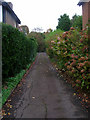
Driveway, Old Shoreham Road
Leading to a house that occupies the area between Old Shoreham Road and Shirley Road.
Image: © Simon Carey
Taken: 11 Nov 2006
0.07 miles
7
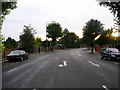
The Upper Drive
The road was built in the 1880s to connect this part of the Stanford's estate with their manor house at Preston. Initially rural in character it is now built up. This stretch is part of the road south of Old Shoreham Road (A270) that turns west to connect with The Drive (B2186). If I had waited 30 seconds longer I would have caught a squirrel crossing the road by the road markings.
Image: © Simon Carey
Taken: 30 Sep 2006
0.08 miles
8
Lincoln Court
Located at the junction of The Drive (B2185) and The Upper Drive. Both roads were laid out when land was developed from the Stanford Estate. These roads linked Hove with Preston where the Stanford family were lords of the manor. Lincoln Court was built on empty land in the early 1960s. This view looks east north east.
Image: © Simon Carey
Taken: 25 Feb 2006
0.08 miles
9
Art Deco Houses, Shirley Road
In between the mock Tudor in this leafy part of Hove are a couple of rudimentary Art Deco designed houses. This area was developed from farmland from the mid 1920s onward.
Image: © Simon Carey
Taken: 11 Nov 2006
0.09 miles