IMAGES TAKEN NEAR TO
The Drive, HOVE, BN3 6GE
Introduction
This page details the photographs taken nearby to The Drive, BN3 6GE by members of the Geograph project.
The Geograph project started in 2005 with the aim of publishing, organising and preserving representative images for every square kilometre of Great Britain, Ireland and the Isle of Man.

There are currently over 7.5m images from over14,400 individuals and you can help contribute to the project by visiting https://www.geograph.org.uk
Image Map
Images are licensed for reuse under creativecommons.org/licenses/by-sa/2.0
Notes
- Clicking on the map will re-center to the selected point.
- The higher the marker number, the further away the image location is from the centre of the postcode.
Image Listing (170 Images Found)
Images are licensed for reuse under creativecommons.org/licenses/by-sa/2.0
Image
Details
Distance
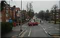
1
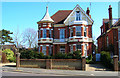
112 The Drive
First of three houses all built in a similar style with the tower and weather vane all on the corner of a junction with Old Shoreham Road and all facing West. This one is on the corner of the junction Old Shoreham Road (A270) and The Drive (B2185). This view looks east towards the house which was erected in the late 1890s and is the only one of three that retains its original design. The other two can be found at Image] and Image
Image: © Simon Carey
Taken: 19 Mar 2006
0.02 miles
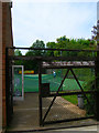
2
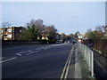
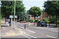
The Monarch's Way on The Drive
On the railway bridge over the West Coastway line looking back along the route towards the Old Shoreham Road.
Image: © Peter Holmes
Taken: 26 Jan 2008
0.03 miles
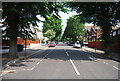
3
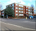
Lincoln Court
Located at the junction of The Drive (B2185) and The Upper Drive. Both roads were laid out when land was developed from the Stanford Estate. These roads linked Hove with Preston where the Stanford family were lords of the manor. Lincoln Court was built on empty land in the early 1960s. This view looks east north east.
Image: © Simon Carey
Taken: 25 Feb 2006
0.04 miles
4
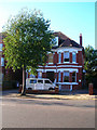
The Drive Prep School
Independent co-educational school based in a big Edwardian villa in The Drive near the junction with the A270 Old Shoreham Road.
Image: © Simon Carey
Taken: 19 Nov 2006
0.05 miles
6
Grasshoppers Tennis Club
A private tennis club sandwiched between the buildings of The Drive and Wilbury Gardens. The clubhouse is on the left. The sign at the back of the courts has been hung upside down.
Image: © Simon Carey
Taken: 4 Jun 2006
0.06 miles
8
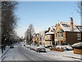
Wilbury Avenue
The part of the residential road that is west of The Drive, the B2185, the day after a major snowfall.
Image: © Simon Carey
Taken: 7 Jan 2010
0.07 miles
10
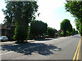
Old Shoreham Road
The A270 Brighton-Shoreham road. It is believed that most of the A270, itself the former A27, was built on the course of an old local Roman road. This stretch lies between Radinden Manor Road and The Drive.
Image: © Simon Carey
Taken: 2 Jul 2006
0.08 miles