IMAGES TAKEN NEAR TO
Lyndhurst Road, HOVE, BN3 6FZ
Introduction
This page details the photographs taken nearby to Lyndhurst Road, BN3 6FZ by members of the Geograph project.
The Geograph project started in 2005 with the aim of publishing, organising and preserving representative images for every square kilometre of Great Britain, Ireland and the Isle of Man.

There are currently over 7.5m images from over14,400 individuals and you can help contribute to the project by visiting https://www.geograph.org.uk
Image Map
Images are licensed for reuse under creativecommons.org/licenses/by-sa/2.0
Notes
- Clicking on the map will re-center to the selected point.
- The higher the marker number, the further away the image location is from the centre of the postcode.
Image Listing (191 Images Found)
Images are licensed for reuse under creativecommons.org/licenses/by-sa/2.0
Image
Details
Distance
1
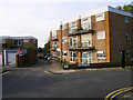
Lyndhurst Court
Tucked into the angle created by the main west coastway and Cliftonville spur railway junction.
Image: © Simon Carey
Taken: 29 Oct 2006
0.01 miles
2
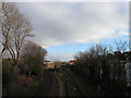
Hove Junction
Looking from Wilbury Villas bridge towards the point where the Cliftonville Spur leaves the West Coastway Line to join with the main London-Brighton line south of Preston Park. This was the first line to built in Sussex connecting Brighton to Shoreham and was opened in 1840, the Cliftonville Spur was added in 1879 to avoid changing at Brighton for those travelling to London.
Image: © Simon Carey
Taken: 14 Jan 2009
0.04 miles
3
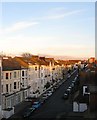
Lyndhurst Road
Looking down towards the western end of the road with Lyndhurst Court the block of flats beyond.
Image: © Simon Carey
Taken: 18 Dec 2009
0.05 miles
4
Holland Road Halt railway station (site), Sussex
Opened in 1905 by the London Brighton & South Coast Railway on the line from Brighton to Portsmouth, this station was adjacent to the site of Hove's first railway station, immediately behind the camera position. See Image In turn, this station, which had two parallel platforms built of timber, closed in 1956. Access was down steps from the Holland Road overbridge.
View west towards the current Hove station and Portsmouth. No trace apparently remains.
Image: © Nigel Thompson
Taken: 13 Jul 2021
0.05 miles
5
Lorna Road, Hove
On the left are Image whilst beyond are numbers 77-91 which were built in 1880 and originally known as Doone Terrace. Much of the northern part of the road had been built by 1900 the southern side was not completed until the 1930s.
Image: © Simon Carey
Taken: 28 Feb 2016
0.05 miles
6
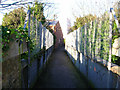
Burton Walk
A small footpath that links Wilbury Avenue with Silverdale Road, taking itself over the Cliftonville Spur railway line in the process. This view is taken from the Silverdale Road end looking north west over the footbridge. The house at the far end is the only residence in Burton Walk. The exit is around the corner just beyond.
Image: © Simon Carey
Taken: 22 Jan 2006
0.05 miles
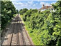
7
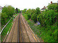
Silverdale Avenue
Starts at the point where Lyndhurst Road turns 90 degrees north takes two turns to the east before ending at Silverdale Road. This section runs parallel with the Cliftonville Spur railway line which is to the left. This view looks north easterly from the first bend in the road.
Image: © Simon Carey
Taken: 5 Mar 2006
0.05 miles
8
Site of Holland Road Halt
Taken from left hand side of here, Image] this spot marks the site of the former station which was an intermediate stop between Brighton and Hove. The platforms were wooden and access was down a flight of stairs on each side from Holland Road. The station was closed in 1956 and nothing remains of its existence today. The line is the west coast one which links Brighton to Portsmouth and it is joined by the Cliftonville Spur, a link that enables trains to bypass Brighton Station, just behind the flats to the right. The bridge in the distance is this, Image] .
Image: © Simon Carey
Taken: 14 May 2006
0.05 miles
9

Brighton to Hove Spur
Viewed from footbridge at Silverdale Avenue Image
Image: © Paul Gillett
Taken: 31 Jan 2010
0.06 miles
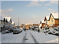
10
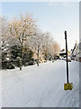
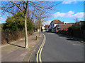
Silverdale Avenue
The road heads north before turning east towards a junction with Silverdale Road. About 10cm of snow fell overnight and by the looks of things nothing has attempted to drive down this road.
Image: © Simon Carey
Taken: 18 Dec 2009
0.06 miles