IMAGES TAKEN NEAR TO
Wilbury Avenue, HOVE, BN3 6FX
Introduction
This page details the photographs taken nearby to Wilbury Avenue, BN3 6FX by members of the Geograph project.
The Geograph project started in 2005 with the aim of publishing, organising and preserving representative images for every square kilometre of Great Britain, Ireland and the Isle of Man.

There are currently over 7.5m images from over14,400 individuals and you can help contribute to the project by visiting https://www.geograph.org.uk
Image Map
Images are licensed for reuse under creativecommons.org/licenses/by-sa/2.0
Notes
- Clicking on the map will re-center to the selected point.
- The higher the marker number, the further away the image location is from the centre of the postcode.
Image Listing (164 Images Found)
Images are licensed for reuse under creativecommons.org/licenses/by-sa/2.0
Image
Details
Distance
1
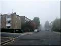
Wilbury Avenue
Looking from the junction with Wilbury Villas towards the crossroads with The Drive which has been obscured by the sea fret that has moved in. Cornwall Court is the block of flats on the corner.
Image: © Simon Carey
Taken: 28 Oct 2009
0.01 miles
2
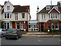
Embassy CES, Wilbury Villas
One of 30 schools in the Brighton and Hove area teaching English as a foreign language to students from abroad. There are three in this square alone plus a purpose built hall of residence.
Image: © Simon Carey
Taken: 30 Apr 2006
0.02 miles
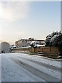
3
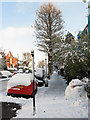
Fat Snowman, Wilbury Avenue
Some people have been enjoying themselves after 10cm of snow had fallen overnight.
Image: © Simon Carey
Taken: 18 Dec 2009
0.03 miles
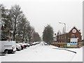
4
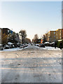
Wilbury Avenue
After 10cm of snow fell overnight a day of driving in sunny, albeit cold weather has compacted the snow at this crossroads making it icy. The weak sun and more plunging temperatures overnight meant that by the following day you needed ice skates to negotiate this road as a pedestrian and this remained so until late on Monday when incoming rains started washing it away.
Image: © Simon Carey
Taken: 18 Dec 2009
0.04 miles
5
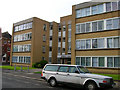
Aynsley Court, Wilbury Avenue
Built in the 1960s on the site of a number of original buildings.
Image: © Simon Carey
Taken: 28 May 2006
0.05 miles
6
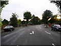
The Upper Drive
The road was built in the 1880s to connect this part of the Stanford's estate with their manor house at Preston. Initially rural in character it is now built up. This stretch is part of the road south of Old Shoreham Road (A270) that turns west to connect with The Drive (B2186). If I had waited 30 seconds longer I would have caught a squirrel crossing the road by the road markings.
Image: © Simon Carey
Taken: 30 Sep 2006
0.05 miles
7
Wilbury Villas
Viewed from the junction of Old Shoreham Road and The Upper Drive. The road was originally a farm track which was laid out towards the end of the 19th century though the first houses did not appear until the first decade of the 20th. The northern end of the road has been cut off from the other two roads.
Image: © Simon Carey
Taken: 20 Jan 2013
0.06 miles
8
Parapet, Wilbury Villas Bridge
The western parapet of the bridge which carries the road over the West Coastway Line. The building beyond is Paris House, a student hall of residence for Bellerbeys language college.
Image: © Simon Carey
Taken: 18 Dec 2009
0.06 miles
9
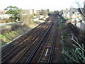
Looking east on the West Coastway line
The main line from Worthing and Littlehampton to London can be seen in the distance branching off to the left just the other side of the Wilbury Villas bridge.
Image: © Peter Holmes
Taken: 26 Jan 2008
0.06 miles
10
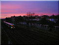
Sunset Over the West Coastway Line
The train has just gone under Drive Bridge to the left whilst the houses on the right are in Wilbury Avenue. The flats by the bridge are Devonshire Court.
Image: © Simon Carey
Taken: 26 Jan 2008
0.06 miles