
IMAGES TAKEN NEAR TO
Mainstone Road, HOVE, BN3 5HL
Introduction
This page details the photographs taken nearby to Mainstone Road, BN3 5HL by members of the Geograph project.
The Geograph project started in 2005 with the aim of publishing, organising and preserving representative images for every square kilometre of Great Britain, Ireland and the Isle of Man.

There are currently over 7.5m images from over14,400 individuals and you can help contribute to the project by visiting https://www.geograph.org.uk
Image Map
Images are licensed for reuse under creativecommons.org/licenses/by-sa/2.0
Notes
- Clicking on the map will re-center to the selected point.
- The higher the marker number, the further away the image location is from the centre of the postcode.
Image Listing (129 Images Found)
Images are licensed for reuse under creativecommons.org/licenses/by-sa/2.0
Image
Details
Distance
1
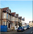
Mainstone Road, Aldrington, Hove
A short residential street linking Marmion Road to Stoneham Road that was constructed in the first decade of the 20th century. The road currently consists of three houses on the western side and a warehouse, in the process of being demolished, on the eastern side.
Image: © Simon Carey
Taken: 17 Dec 2016
0.02 miles
2
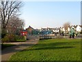
Stoneham Park, Aldrington, Hove
Small park on Marmion Road that was given over for public use by the Duke of Portland in 1906. The land had previously been a gravel pit. There is not a great deal of greenery here with much of the park being tarmac and includes an enclosed area for football and basketball as well as a separate playground area. Out of shot to the right is The Hive, the park cafe which is owned and run by a local community group. As the only open space in a densely populated area it is a very popular local utility.
Image: © Simon Carey
Taken: 22 Jan 2017
0.03 miles
3
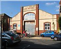
Hove Drill Hall, Marmion Road, Hove
Appears on the 1911 OS map and built before the rest of the houses to the west of it. Still in use today by both Army Cadets and Hove and Adur Sea cadets.
Image: © Simon Carey
Taken: 2 Oct 2015
0.04 miles
4
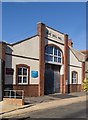
Hove Drill Hall
http://www.drillhalls.org/Counties/Sussex/TownHove.htm
Image: © Jim Osley
Taken: 4 Aug 2020
0.04 miles
5
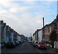
Stoneham Road, Aldrington, Hove
A reisdential road laid out around 1901-02 that runs west from Tamworth Road ending at the rear of commercial buildings that face School Road. The large building in the distance on the left is Image
Image: © Simon Carey
Taken: 17 Dec 2016
0.04 miles
6
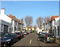
Scott Road, Aldrington, Hove
A short residential street that links Portland Road to Marmion Road that was developed in the first decade of the 20th century. The trees mark the site of Stoneham Park.
Image: © Simon Carey
Taken: 17 Dec 2016
0.04 miles
7
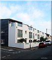
29a-29h, Stoneham Road, Aldrington, Hove
Located between Linton Road and Lennox Road and built in 2008 on the site of Stoneham Road Baptist Church that had been built in 1904. See http://www.roughwood.net/ChurchAlbum/EastSussex/Hove/Hove-Stoneham-Road-Baptist.htm
Image: © Simon Carey
Taken: 17 Dec 2016
0.04 miles
8
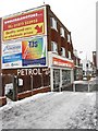
Used Car Dealer, Portland Road
Festooned with billboards and an advert from the pre-decimal age. If only petrol was sixpence today. That at least dates the building to the 1960s.
Image: © Simon Carey
Taken: 2 Dec 2010
0.04 miles
9
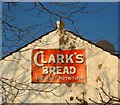
Old Sign, Stoneham Park, Aldrington, Hove
On the rear of a house in Stoneham Road, see Image, and viewed from the park. Clark's was a local bakery with its main premises in Newtown Road that opened in 1887 and operated until 1976 when it fell into insolvency, having sold part of its business in the summer of that year to Rank Hovis McDougall, then abruptly closed in October when another takeover failed to materialise. The company's name still survives in a number of law textbooks as the legal battle after insolvency continued on to the end of the decade. Decisions included the definition of an establishment being one firm (Clark's had claimed their bakery and 28 shops were separate establishments) and that insolvency wasn't a special case to dismiss workers (Clark's had not informed workers of the gradual run down of the company and just locked the gates and dismissed employers on the day a potential deal collapsed).
Image: © Simon Carey
Taken: 22 Jan 2017
0.04 miles
10
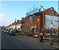
17 Marmion Road, Aldrington, Hove
In the process of being demolished. Purpose built for the YMCA in 1919 who occupied it until moving out in the summer of 2015 no longer able to justify the large expenditure on maintaining the building. The main entrance and east wing have already been demolished with the west wing about to go. Five new homes are to be built on the site.
Image: © Simon Carey
Taken: 17 Dec 2016
0.05 miles