1
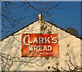
Old Sign, Stoneham Park, Aldrington, Hove
On the rear of a house in Stoneham Road, see
Image, and viewed from the park. Clark's was a local bakery with its main premises in Newtown Road that opened in 1887 and operated until 1976 when it fell into insolvency, having sold part of its business in the summer of that year to Rank Hovis McDougall, then abruptly closed in October when another takeover failed to materialise. The company's name still survives in a number of law textbooks as the legal battle after insolvency continued on to the end of the decade. Decisions included the definition of an establishment being one firm (Clark's had claimed their bakery and 28 shops were separate establishments) and that insolvency wasn't a special case to dismiss workers (Clark's had not informed workers of the gradual run down of the company and just locked the gates and dismissed employers on the day a potential deal collapsed).
Image: © Simon Carey
Taken: 22 Jan 2017
0.02 miles
2
Stoneham Park, Aldrington, Hove
Small park on Marmion Road that was given over for public use by the Duke of Portland in 1906. The land had previously been a gravel pit. There is not a great deal of greenery here with much of the park being tarmac and includes an enclosed area for football and basketball as well as a separate playground area. Out of shot to the right is The Hive, the park cafe which is owned and run by a local community group. As the only open space in a densely populated area it is a very popular local utility.
Image: © Simon Carey
Taken: 22 Jan 2017
0.03 miles
3
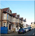
Stoneham News, Stoneham Road, Aldrington, Hove
A local newsagent opposite the junction with Ruskin Road. One of the houses on the right has
Image fixed to its southern side.
Image: © Simon Carey
Taken: 22 Jan 2017
0.03 miles
4
A wet day in Kendal Road, Hove
Image: © nick macneill
Taken: 23 Feb 2010
0.03 miles
5
Mainstone Road, Aldrington, Hove
A short residential street linking Marmion Road to Stoneham Road that was constructed in the first decade of the 20th century. The road currently consists of three houses on the western side and a warehouse, in the process of being demolished, on the eastern side.
Image: © Simon Carey
Taken: 17 Dec 2016
0.04 miles
6
New houses, Hove
Amid the Victorian houses of this area, known locally as "Poets' Corner", is this small group of new houses on Stoneham Road.
Image: © Stephen Richards
Taken: 27 Dec 2009
0.04 miles
7
Hove : murals, Stoneham Park
Image: © Jim Osley
Taken: 21 Feb 2019
0.04 miles
8
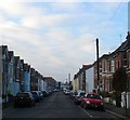
Stoneham Road, Aldrington, Hove
A reisdential road laid out around 1901-02 that runs west from Tamworth Road ending at the rear of commercial buildings that face School Road. The large building in the distance on the left is
Image
Image: © Simon Carey
Taken: 17 Dec 2016
0.05 miles
9
29a-29h, Stoneham Road, Aldrington, Hove
Located between Linton Road and Lennox Road and built in 2008 on the site of Stoneham Road Baptist Church that had been built in 1904. See http://www.roughwood.net/ChurchAlbum/EastSussex/Hove/Hove-Stoneham-Road-Baptist.htm
Image: © Simon Carey
Taken: 17 Dec 2016
0.05 miles
10
Ghost sign, Hove
Image: © Jim Osley
Taken: 8 Oct 2016
0.06 miles


