IMAGES TAKEN NEAR TO
Stoneham Road, HOVE, BN3 5HH
Introduction
This page details the photographs taken nearby to Stoneham Road, BN3 5HH by members of the Geograph project.
The Geograph project started in 2005 with the aim of publishing, organising and preserving representative images for every square kilometre of Great Britain, Ireland and the Isle of Man.

There are currently over 7.5m images from over14,400 individuals and you can help contribute to the project by visiting https://www.geograph.org.uk
Image Map
Images are licensed for reuse under creativecommons.org/licenses/by-sa/2.0
Notes
- Clicking on the map will re-center to the selected point.
- The higher the marker number, the further away the image location is from the centre of the postcode.
Image Listing (125 Images Found)
Images are licensed for reuse under creativecommons.org/licenses/by-sa/2.0
Image
Details
Distance
1
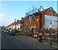
17 Marmion Road, Aldrington, Hove
In the process of being demolished. Purpose built for the YMCA in 1919 who occupied it until moving out in the summer of 2015 no longer able to justify the large expenditure on maintaining the building. The main entrance and east wing have already been demolished with the west wing about to go. Five new homes are to be built on the site.
Image: © Simon Carey
Taken: 17 Dec 2016
0.02 miles
2
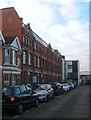
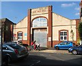
80, Stoneham Road, Aldrington, Hove
Built as a factory in 1902 and first occupied by a mineral water company from 1904-12. After the First World War it was acquired by Maynards who produced sweets as well as acting as a distribution depot for local shops. They ceased operating here in 1962 with the building eventually converted into apartments in 2002.
Image: © Simon Carey
Taken: 17 Dec 2016
0.02 miles
3
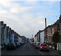
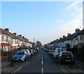
Stoneham Road, Aldrington, Hove
A reisdential road laid out around 1901-02 that runs west from Tamworth Road ending at the rear of commercial buildings that face School Road. The large building in the distance on the left is Image
Image: © Simon Carey
Taken: 17 Dec 2016
0.03 miles
4
29a-29h, Stoneham Road, Aldrington, Hove
Located between Linton Road and Lennox Road and built in 2008 on the site of Stoneham Road Baptist Church that had been built in 1904. See http://www.roughwood.net/ChurchAlbum/EastSussex/Hove/Hove-Stoneham-Road-Baptist.htm
Image: © Simon Carey
Taken: 17 Dec 2016
0.03 miles
5
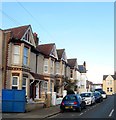
Marmion Road, Aldrington, Hove
A residential road that links School Road to Tamworth Road that had been laid out by 1911 but not completed until the end of the decade.
Image: © Simon Carey
Taken: 17 Dec 2016
0.03 miles
6
Hove Drill Hall, Marmion Road, Hove
Appears on the 1911 OS map and built before the rest of the houses to the west of it. Still in use today by both Army Cadets and Hove and Adur Sea cadets.
Image: © Simon Carey
Taken: 2 Oct 2015
0.04 miles
7
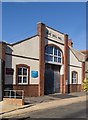
Hove Drill Hall
http://www.drillhalls.org/Counties/Sussex/TownHove.htm
Image: © Jim Osley
Taken: 4 Aug 2020
0.04 miles
8
Mainstone Road, Aldrington, Hove
A short residential street linking Marmion Road to Stoneham Road that was constructed in the first decade of the 20th century. The road currently consists of three houses on the western side and a warehouse, in the process of being demolished, on the eastern side.
Image: © Simon Carey
Taken: 17 Dec 2016
0.04 miles
9

Linton Road, Hove
Taken because of the unusually blue early evening light. The shot has not been tampered with.
Image: © Stephen Richards
Taken: 26 Dec 2009
0.06 miles
10
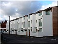
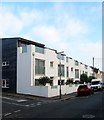
New houses, Hove
Amid the Victorian houses of this area, known locally as "Poets' Corner", is this small group of new houses on Stoneham Road.
Image: © Stephen Richards
Taken: 27 Dec 2009
0.06 miles