IMAGES TAKEN NEAR TO
Payne Avenue, HOVE, BN3 5HB
Introduction
This page details the photographs taken nearby to Payne Avenue, BN3 5HB by members of the Geograph project.
The Geograph project started in 2005 with the aim of publishing, organising and preserving representative images for every square kilometre of Great Britain, Ireland and the Isle of Man.

There are currently over 7.5m images from over14,400 individuals and you can help contribute to the project by visiting https://www.geograph.org.uk
Image Map
Images are licensed for reuse under creativecommons.org/licenses/by-sa/2.0
Notes
- Clicking on the map will re-center to the selected point.
- The higher the marker number, the further away the image location is from the centre of the postcode.
Image Listing (153 Images Found)
Images are licensed for reuse under creativecommons.org/licenses/by-sa/2.0
Image
Details
Distance
1
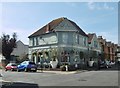
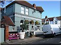
Aldrington, George Payne
Public house on Payne Avenue. L-shaped back counter, with eating and drinking areas left, front and right; background music, TV, beer garden and outside seating. Cask ales on offer at my visit: Gun Extra Pale, Harvey's Sussex Best, Robinson's Blonde.
Image: © Mike Faherty
Taken: 15 Sep 2018
0.01 miles
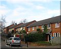
2
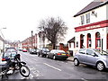
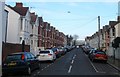
Payne Avenue, Aldrington, Hove
A residential road that heads east from the junction with Alpine Road to Ruskin Road in the distance. Laid out in the first years of the 20th century and named after its developer, George Payne.
Image: © Simon Carey
Taken: 17 Dec 2016
0.02 miles
3
George Payne, Payne Avenue, Aldrington, Hove
A public house located on the corner of Kendal Road that was built around 1901 and originally named the Kendal Arms. The pub was renamed around 2012 in order to distance itself from a poor reputation and reinstate itself as part of the whole community. George Payne was the name of the builder who developed the surrounding area.
Image: © Simon Carey
Taken: 17 Dec 2016
0.02 miles
4
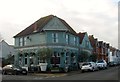
The George Payne, formerly Kendal Arms
Image: © Alex McGregor
Taken: 13 Aug 2014
0.02 miles
5
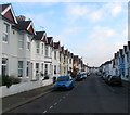
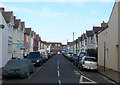
Kendal Road, Aldrington, Hove
A residential road that links Stoneham Road to Payne Avenue that was built around 1902.
Image: © Simon Carey
Taken: 17 Dec 2016
0.03 miles
6
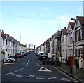
Lennox Road, Aldrington, Hove
A residential road that connects Stoneham Road to Payne Avenue that was built in the first years of the 20th century.
Image: © Simon Carey
Taken: 17 Dec 2016
0.05 miles
7
Ruskin Road, Aldrington, Hove
A residential road that heads north from Stoneham Road and ends next to the railway. It was developed around 1902.
Image: © Simon Carey
Taken: 17 Dec 2016
0.05 miles
8
Ruskin Place, Aldrington, Hove
A named path that lies between Tamworth Road and Ruskin Road. The houses were built around 2001 on the site of a former factory occupied by TB Colman & Son who made revolving doors. The company also had another site at Image
Image: © Simon Carey
Taken: 17 Dec 2016
0.06 miles
9
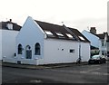
Payne Hall Cottage, Payne Avenue, Aldrington, Hove
Located on the corner of Linton Road is a former Cokelers chapel that was built around 1906 and closed in 1978. The building has now been converted into a residence.
Image: © Simon Carey
Taken: 17 Dec 2016
0.06 miles