IMAGES TAKEN NEAR TO
Molesworth Street, HOVE, BN3 5FL
Introduction
This page details the photographs taken nearby to Molesworth Street, BN3 5FL by members of the Geograph project.
The Geograph project started in 2005 with the aim of publishing, organising and preserving representative images for every square kilometre of Great Britain, Ireland and the Isle of Man.

There are currently over 7.5m images from over14,400 individuals and you can help contribute to the project by visiting https://www.geograph.org.uk
Image Map
Images are licensed for reuse under creativecommons.org/licenses/by-sa/2.0
Notes
- Clicking on the map will re-center to the selected point.
- The higher the marker number, the further away the image location is from the centre of the postcode.
Image Listing (137 Images Found)
Images are licensed for reuse under creativecommons.org/licenses/by-sa/2.0
Image
Details
Distance
1
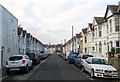
Molesworth Street, Aldrington, Hove
A residential street that links Tamworth Road to Rutland Road that was constructed at the end of the 1890s.
Image: © Simon Carey
Taken: 17 Dec 2016
0.01 miles
2
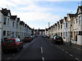
Mortimer Road, Aldrington, Hove
A residential street running east from Tamworth Road becoming Arthur Street at the junction with Rutland Road. The road had been laid out by the time of the 1898 OS maps and probably completed soon after.
Image: © Simon Carey
Taken: 17 Dec 2016
0.02 miles
3
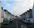
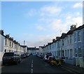
Molesworth Street
In the area known as Poet's Corner due to the street names all being named after poets rather than anything resembling a Bohemian lifestyle. Much of the housing is terraced built for the tradesman who serviced the great and good in the villas between Portland Road and the sea. This street links Rutland Road to Tamworth Road.
Image: © Simon Carey
Taken: 14 Jan 2009
0.02 miles
4

Access to Aldrington Station
Opened as a halt in 1905 the station had rudimentary access and facilities, both sides having long walks to the nearest road. This is the path for those wishing to catch westbound trains with the rear of houses in Mortimer Road to the left.
Image: © Simon Carey
Taken: 14 Jan 2009
0.04 miles
5
Suffolk Street, Aldrington, Hove
A residential street that links Tamworth Road to Rutland Road that was completed by the late 1890s.
Image: © Simon Carey
Taken: 17 Dec 2016
0.04 miles
6
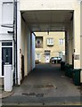
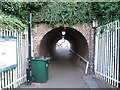
Mortimer Mews, Aldrington, Hove
There are six dwellings within the mews accessed through this arch off Mortimer Road. They built about fifteen years ago on the site of a former works owned by TB Colman & Sons whose main factory was located at Image
Image: © Simon Carey
Taken: 17 Dec 2016
0.04 miles
7
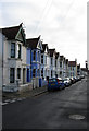
Tamworth Road
In the area known as Poet's Corner due to the street names all being named after poets rather than anything resembling a Bohemian lifestyle. Much of the housing is terraced built for the tradesman who serviced the great and good in the villas between Portland Road and the sea. St Paul's Roman Catholic Church on Portland Road can be seen in the distance.
Image: © Simon Carey
Taken: 14 Jan 2009
0.05 miles

9
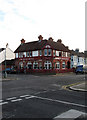
Ancient Mariner, Rutland Road
Though it is on the corner of Coleridge Street, once known as the Rutland the name change has only occurred in the last few years. Located in the area known as Poet's Corner due to the street names all being named after poets rather than anything resembling a Bohemian lifestyle. Much of the housing is terraced built for the tradesman who serviced the great and good in the villas between Portland Road and the sea. Taken from Rutland Road's junction with Molesworth Street.
Image: © Simon Carey
Taken: 14 Jan 2009
0.05 miles