IMAGES TAKEN NEAR TO
Saxon Road, HOVE, BN3 4LE
Introduction
This page details the photographs taken nearby to Saxon Road, BN3 4LE by members of the Geograph project.
The Geograph project started in 2005 with the aim of publishing, organising and preserving representative images for every square kilometre of Great Britain, Ireland and the Isle of Man.

There are currently over 7.5m images from over14,400 individuals and you can help contribute to the project by visiting https://www.geograph.org.uk
Image Map
Images are licensed for reuse under creativecommons.org/licenses/by-sa/2.0
Notes
- Clicking on the map will re-center to the selected point.
- The higher the marker number, the further away the image location is from the centre of the postcode.
Image Listing (243 Images Found)
Images are licensed for reuse under creativecommons.org/licenses/by-sa/2.0
Image
Details
Distance
1
Electricity Substation, Saxon Road, Aldrington, Hove
One of two on the road, see also Image, that were built in the 1930s.
Image: © Simon Carey
Taken: 22 Dec 2016
0.02 miles
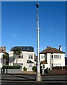
2
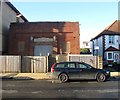
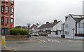
Tandridge Road, Aldrington, Hove
A residential road that originally linked Kingsway, the A259, to Marine Avenue though the junction at the former has now been blocked off. The road had been laid out by 1911 with building commencing before the First World War but not completed until the 1920s.
Image: © Simon Carey
Taken: 14 Dec 2016
0.04 miles
4
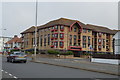
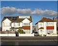
Saxon Court, Kingsway, Aldrington, Hove
The current block of flats were built as sheltered housing in 1989 and are located on the corner of Saxon Road. The spot was the original site of a filling station opened in 1924 that also dealt in car sales. It remained in use as a garage until the 1980s when it was demolished.
See:
Garage 1923 - http://regencysociety-jamesgray.com/volume15/source/jg_15_073.html
Garage 1926 - http://regencysociety-jamesgray.com/volume15/source/jg_15_089.html
Image: © Simon Carey
Taken: 4 Dec 2016
0.05 miles
6
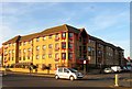
315-319, Kingsway, Aldrington, Hove
Located next to the junction with Saxon Road and built in the late 1920s.
Image: © Simon Carey
Taken: 3 Dec 2016
0.06 miles
7
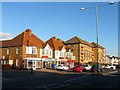
323-329, Kingsway, Aldrington, Hove
A small parade of shops that includes a cafe, newsagents and retailers of curtains and fishing equipment. Beyond is Saxon Court, a set of retirement flats built in 1989 on the site of a former garage that first opened in 1923.
Image: © Simon Carey
Taken: 3 Dec 2016
0.06 miles
8
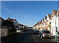
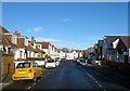
Marine Avenue, Aldrington, Hove
A residential road that links Wish Road to the east with Saxon Road to the west. The northern side was mostly developed prior to 1911 with the southern side completed by the 1920s. Of the 29 residential road that are located between Westbourne Place on the old parish boundary to the east, Boundary Road to the west, New Church Road to the north and Kingsway to the south only 4 run east-west these being Marine Avenue, Glastonbury Road, Kenton Road and Seaford Road. The rest run north-south.
Image: © Simon Carey
Taken: 14 Dec 2016
0.06 miles
9
311-313, Kingsway, Aldrington, Hove
Two houses located next to the junction of Tandridge Road which were built in the 1920s.
Image: © Simon Carey
Taken: 14 Dec 2016
0.07 miles
10
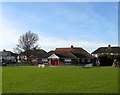
Saxon Road Pavilion, Aldrington Recreation Ground (Wish Park), Hove
Dating from the 1960s and located on the western side of the park.
Image: © Simon Carey
Taken: 14 Dec 2016
0.07 miles