IMAGES TAKEN NEAR TO
Welbeck Avenue, HOVE, BN3 4JQ
Introduction
This page details the photographs taken nearby to Welbeck Avenue, BN3 4JQ by members of the Geograph project.
The Geograph project started in 2005 with the aim of publishing, organising and preserving representative images for every square kilometre of Great Britain, Ireland and the Isle of Man.

There are currently over 7.5m images from over14,400 individuals and you can help contribute to the project by visiting https://www.geograph.org.uk
Image Map
Images are licensed for reuse under creativecommons.org/licenses/by-sa/2.0
Notes
- Clicking on the map will re-center to the selected point.
- The higher the marker number, the further away the image location is from the centre of the postcode.
Image Listing (134 Images Found)
Images are licensed for reuse under creativecommons.org/licenses/by-sa/2.0
Image
Details
Distance
1
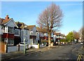
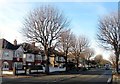
38-46, Welbeck Avenue, Aldrington, Hove
Houses on the western side of the road built in the mid 1920s. Numbers 42-46 were built on the site of Wish Barn a complex of flint outbuildings which for many decades were the only structures within the open fields of the parish of Aldrington, See http://regencysociety-jamesgray.com/volume15/source/jg_15_119.html . The barns were removed around 1926.
Image: © Simon Carey
Taken: 14 Dec 2016
0.03 miles
2
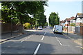
Berriedale Avenue, Aldrington, Hove
A residential road that links Kingsway, the A259, to New Church Road, the B2066 that was developed between 1926-27.
Image: © Simon Carey
Taken: 14 Dec 2016
0.05 miles
3
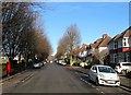
Wish Road, Aldrington, Hove
A residential road linking Kingsway, the A259, to New Church Road, the B2066. The road was originally an old farm track which ran northwards from the coast road to provide access to Wish Barn, see Image, Wish Cottage, see Image, and from 1895 Image The road was named on the 1911 OS map though lacking buildings. These were developed in the early 1920s.
Image: © Simon Carey
Taken: 14 Dec 2016
0.06 miles

6
114-124, New Church Road, Aldrington, Hove
Located between Welbeck Avenue and Wish Road on the southern side of the B2066. Numbers 120-124, on the right, had been completed by the 1932 OS map, 114-118 soon after.
Image: © Simon Carey
Taken: 14 Dec 2016
0.07 miles
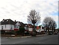
7
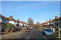
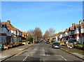
Welbeck Avenue, Aldrington, Hove
A residential road that links Kingsway, the A259, to New Church Road, the B2066. The road was developed around 1926-27.
Image: © Simon Carey
Taken: 14 Dec 2016
0.07 miles
8
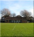
Changing Rooms, Aldrington Recreation Ground (Wish Park), Hove
On the eastern side adjacent to Wish Road and also containing public lavatories on the southern side and a small cafe on the northern side. Built in the early 1970s to replace an older corrugated iron structure, see http://regencysociety-jamesgray.com/volume15/source/jg_15_118.html
Image: © Simon Carey
Taken: 14 Dec 2016
0.07 miles
9
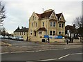
Sussex Medical Centre
Private GP surgery at the corner of Wish Road and New Church Road http://www.sussexmedicalchambers.co.uk/aboutus.php
Image: © Paul Gillett
Taken: 9 Mar 2012
0.08 miles
10
96-104, New Church Road, Aldrington, Hove
Individual houses located between Braemore Road and Berriedale Avenue and built in the mid 1920s.
Image: © Simon Carey
Taken: 14 Jan 2017
0.08 miles