IMAGES TAKEN NEAR TO
Carlisle Road, HOVE, BN3 4FS
Introduction
This page details the photographs taken nearby to Carlisle Road, BN3 4FS by members of the Geograph project.
The Geograph project started in 2005 with the aim of publishing, organising and preserving representative images for every square kilometre of Great Britain, Ireland and the Isle of Man.

There are currently over 7.5m images from over14,400 individuals and you can help contribute to the project by visiting https://www.geograph.org.uk
Image Map
Images are licensed for reuse under creativecommons.org/licenses/by-sa/2.0
Notes
- Clicking on the map will re-center to the selected point.
- The higher the marker number, the further away the image location is from the centre of the postcode.
Image Listing (157 Images Found)
Images are licensed for reuse under creativecommons.org/licenses/by-sa/2.0
Image
Details
Distance
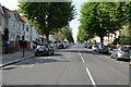
3
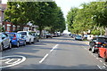
Walsingham Road, Aldrington, Hove
A residential road linking Kingsway, the A259, to New Church Road, the B2066. Laid out in the 1890s it was partially developed by the time of the 1898 OS map and completed by the 1911 edition.
Image: © Simon Carey
Taken: 11 Dec 2016
0.08 miles
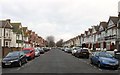
4
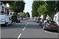
Langdale Road
Residential street linking Kingsway, the A259, with New Church Road, the B2066. The side roads were driveable a few hours after 10cm of snow had been deposited overnight but would prove to be far more dangerous on the following day when overnight freezing temperatures turned the slush and compacted snow into ice rinks.
Image: © Simon Carey
Taken: 18 Dec 2009
0.08 miles
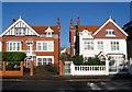
5
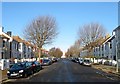
32-34, Walsingham Road, Aldrington, Hove
Part of a group (Numbers 18-48) of semi-detached houses built in the same style along the western side of the road sometime during the first decade of the 20th century.
Image: © Simon Carey
Taken: 11 Dec 2016
0.08 miles
6
63-65, New Church Road, Aldrington, Hove
Image: © Simon Carey
Taken: 11 Dec 2016
0.09 miles
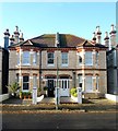
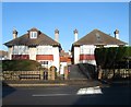
8
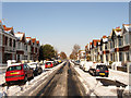
Carlisle Road, Aldrington, Hove
A residential road that runs between Kingsway, the A259, and New Church Road, the B2066 that was built in the 1890s. Its most famous resident was disgraced former MP Charles Stewart Parnell who died in a house in this street in 1891.
Image: © Simon Carey
Taken: 14 Jan 2017
0.09 miles
9
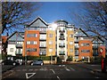
Coastal Place, New Church Road, Aldrington, Hove
Occupying the former sites of numbers 55-61 New Church Road. Number 55 was located on the eastern side and was built just before the start of the First World War in large grounds. The house was demolished in the mid 1960s but remained vacant for another decade until the plot was purchased by Nuffield Hospital, a private medical institution. They opened in 1976 and operated here until 2004 when patients were moved to a larger modern block in Woodingdean. The hospital was demolished around 2006. Numbers 59-61 were built at the same time as neighbouring Image and survived into the 1980s when they too were demolished for an extension to the hospital. The flats contain 70 homes and were constructed around 2007-08.
See http://regencysociety-jamesgray.com/volume15/source/jg_15_136.html for an image of number 55.
Image: © Simon Carey
Taken: 11 Dec 2016
0.09 miles
10
67-69, New Church Road, Aldrington, Hove
Located next to the junction of Richardson Road and built around 1920. Number 67 is on the right.
Image: © Simon Carey
Taken: 11 Dec 2016
0.09 miles