IMAGES TAKEN NEAR TO
New Church Road, HOVE, BN3 4FH
Introduction
This page details the photographs taken nearby to New Church Road, BN3 4FH by members of the Geograph project.
The Geograph project started in 2005 with the aim of publishing, organising and preserving representative images for every square kilometre of Great Britain, Ireland and the Isle of Man.

There are currently over 7.5m images from over14,400 individuals and you can help contribute to the project by visiting https://www.geograph.org.uk
Image Map
Images are licensed for reuse under creativecommons.org/licenses/by-sa/2.0
Notes
- Clicking on the map will re-center to the selected point.
- The higher the marker number, the further away the image location is from the centre of the postcode.
Image Listing (168 Images Found)
Images are licensed for reuse under creativecommons.org/licenses/by-sa/2.0
Image
Details
Distance
1
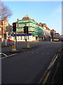
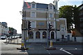
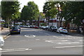
A2023/B2066 Crossroads, Hove
Where the A2023 (north-south) meets the B2066 (east-west). Clockwise; Sackville Road heads north, Church Road east, Hove Street south and New Church Road west. This point also marks the western most edge of Hove's shopping area.
Image: © Simon Carey
Taken: 1 Jan 2007
0.02 miles
3
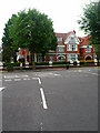
The Priory, New Church Road
Private hospital on the B2066 converted from early twentieth century townhouses.
Image: © Simon Carey
Taken: 1 Jul 2007
0.03 miles
5
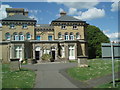
Hove Museum & Art Gallery
Hove Museum & Art Gallery is a handsome, late 19th century Italianate Victorian villa originally called Brooker Hall. It was designed by architect Thomas Lainson and built for John Oliver Vallance
Alongside significant collections of toys, pioneering film ephemera, local history and fine art displays, Hove Museum boasts one of the finest craft collections in the country
http://www.brighton-hove-rpml.org.uk/Museums/hovemuseum/Pages/home.aspx
Image: © Paul Gillett
Taken: 26 May 2009
0.03 miles
8
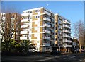
Pembroke Court, New Church Road, Hove
Block of flats built in the 1960s located on the corner of Pembroke Avenue. See http://regencysociety-jamesgray.com/volume15/source/jg_15_096.html for the large Edwardian House, numbered 15, it replaced.
Image: © Simon Carey
Taken: 11 Dec 2016
0.04 miles
9
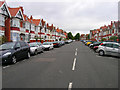
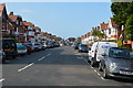
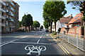
Aymer Road
Linking Princes Avenue with New Church Road is the first of a number of roads built on the site of former brickfields used to construct much of Victorian Hove.
Image: © Simon Carey
Taken: 1 Jul 2007
0.05 miles
10
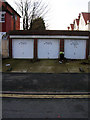
Garages, Sackville Road
On the junction of Sackville Road and Pembroke Crescent whose houses can be seen on the right hand side.
Image: © Simon Carey
Taken: 1 Jan 2007
0.05 miles