IMAGES TAKEN NEAR TO
Walsingham Road, HOVE, BN3 4FE
Introduction
This page details the photographs taken nearby to Walsingham Road, BN3 4FE by members of the Geograph project.
The Geograph project started in 2005 with the aim of publishing, organising and preserving representative images for every square kilometre of Great Britain, Ireland and the Isle of Man.

There are currently over 7.5m images from over14,400 individuals and you can help contribute to the project by visiting https://www.geograph.org.uk
Image Map (Loading...)


Getting Data...Please wait
Leaflet Map data © OpenStreetMap
Images are licensed for reuse under creativecommons.org/licenses/by-sa/2.0
Notes
- Clicking on the map will re-center to the selected point.
- The higher the marker number, the further away the image location is from the centre of the postcode.
Image Listing (181 Images Found)
Images are licensed for reuse under creativecommons.org/licenses/by-sa/2.0
Image
Details
Distance
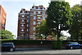
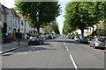
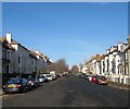
1
Walsingham Road, Aldrington, Hove
A residential road linking Kingsway, the A259, to New Church Road, the B2066. Laid out in the 1890s it was partially developed by the time of the 1898 OS map and completed by the 1911 edition.
Image: © Simon Carey
Taken: 11 Dec 2016
0.03 miles
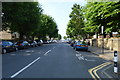
2
32-34, Walsingham Road, Aldrington, Hove
Part of a group (Numbers 18-48) of semi-detached houses built in the same style along the western side of the road sometime during the first decade of the 20th century.
Image: © Simon Carey
Taken: 11 Dec 2016
0.05 miles
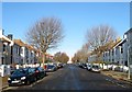
3
Sackville Gardens, Aldrington, Hove
A resindential road that links Kingsway, the A259, to New Church Road, the B2066. It was laid out in the 1890s had been partially built by the time of the 1898 OS map and completed by the 1911 edition.
Image: © Simon Carey
Taken: 11 Dec 2016
0.05 miles
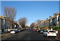
7
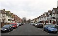
Carlisle Road, Aldrington, Hove
A residential road that runs between Kingsway, the A259, and New Church Road, the B2066 that was built in the 1890s. Its most famous resident was disgraced former MP Charles Stewart Parnell who died in a house in this street in 1891.
Image: © Simon Carey
Taken: 14 Jan 2017
0.10 miles
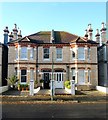
8
Westbourne Villas, Aldrington, Hove
A residential road that runs between Kingsway, the A259, and New church Road, the B2066. The road was developed in the 1890s with the exception of a couple of small plots at the northern end and are a mixture of two and three storey Victorian houses.
Image: © Simon Carey
Taken: 11 Dec 2016
0.10 miles
9
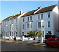
13-19, Walsingham Road, Aldrington, Hove
The surviving three storey houses at the south eastern end of the road that were built in the 1890s. Numbers 1-11 were lost to the construction of Image
Image: © Simon Carey
Taken: 11 Dec 2016
0.10 miles