IMAGES TAKEN NEAR TO
New Church Road, HOVE, BN3 4DB
Introduction
This page details the photographs taken nearby to New Church Road, BN3 4DB by members of the Geograph project.
The Geograph project started in 2005 with the aim of publishing, organising and preserving representative images for every square kilometre of Great Britain, Ireland and the Isle of Man.

There are currently over 7.5m images from over14,400 individuals and you can help contribute to the project by visiting https://www.geograph.org.uk
Image Map
Images are licensed for reuse under creativecommons.org/licenses/by-sa/2.0
Notes
- Clicking on the map will re-center to the selected point.
- The higher the marker number, the further away the image location is from the centre of the postcode.
Image Listing (78 Images Found)
Images are licensed for reuse under creativecommons.org/licenses/by-sa/2.0
Image
Details
Distance
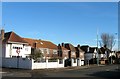
1
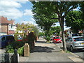
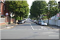
New Church Road
One of Hove's longest at 2.3km (1.4 miles) and straightest roads, New Church Road runs from Portslade Boundary Road to Hove's Sackville Road
Image: © Paul Gillett
Taken: 26 May 2009
0.03 miles
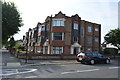
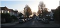
3
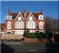
143-145, New Church Road, Aldrington, Hove
Built in the first decade of the 20th century for a number of years the only residences between St Leonard's and St Philip's churches, see https://jackiedinnis.files.wordpress.com/2013/08/aldrington-park-copy.jpg to get some idea of the isolation. Now located on the western corner of Portland Avenue.
Image: © Simon Carey
Taken: 14 Dec 2016
0.04 miles
6
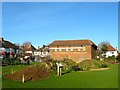
Electricity Substation, Saxon Road, Aldrington, Hove
The barn like structure is located in the north west corner of Wish Park and was constructed in the 1920s.
Image: © Simon Carey
Taken: 14 Dec 2016
0.06 miles
7
Mornington Mansions, New Church Road, Aldrington, Hove
Block of flats located on the corner of Roman Road that was built in 1934.
Image: © Simon Carey
Taken: 3 Dec 2016
0.06 miles
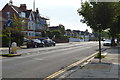
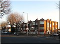
9
131-141, New Church Road, Aldrington, Hove
Looking eastwards with number 141 on the corner of Portland Avenue. Largely built during the 1920s with the exception of 137-139 which were completed by the late 1930s.
Image: © Simon Carey
Taken: 14 Dec 2016
0.08 miles
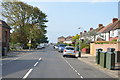
10
Mornington Crescent, Aldrington, Hove
A residential road that heads north from New Church Road and ends at the junction with Rothbury Road and Jesmond Road. Originally part of an open space called Old Field according to Aldrington's 1840 tithe map that was developed in the 1930s.
Image: © Simon Carey
Taken: 3 Dec 2016
0.08 miles