1
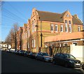
West Hove Infants School, Connaught Road, Hove
Built in 1884 and opened as the Connaught Road School. During a reorganisation of education in the 1940s part of the building became Hove Manor Secondary School until its closure in 1967. It then became Connaught Road First School until 1984 when the building was deemed unfit for children's education. Subsequently, it was converted into an adult education centre until swingeing further education cuts forced its owners, City college, to close the campus in 2010. During the latter period the school was listed as an example of the work of Thomas Simpson, a forward thinking designer of school buildings in the area, and the last one within the city left standing. Subsequently, the site was taken over by West Hove Infants and reopened in September 2011 returning the building to its original use.
Image: © Simon Carey
Taken: 18 Feb 2017
0.03 miles
2
Connaught Rd
Image: © N Chadwick
Taken: 4 Jul 2015
0.03 miles
3
Sackville Road
Sackville Rd is the A2023 that runs north from the sea front in Hove. there are some interesting Victorian Houses on this section between Church Rd and Stirling Place.
Image: © Nigel Mykura
Taken: 13 Feb 2011
0.04 miles
4
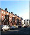
5-11, Sackville Road, Hove
Just to the north of the junction with Church Road and built in the 1880s when Sackville Road began to be developed. Previously it had been an old droveway known as Hove Drove.
Image: © Simon Carey
Taken: 18 Feb 2017
0.04 miles
5
A2023
Image: © N Chadwick
Taken: 4 Jul 2015
0.05 miles
6
Hove Library
Located on Church Road opposite the new Tesco and built in 1908, it recently celebrated its centenary.
Image: © Simon Carey
Taken: 18 Dec 2009
0.05 miles
7
The junction of Hove Street and (opposite) Sackville Road with Church Road, Hove
Hove Street, becoming Sackville Road, is the A 2023. Church Road is the B2066.
Image: © Ruth Sharville
Taken: 29 Sep 2023
0.06 miles
8
Pedimented gable, Stirling Place, Hove
Image: © Jim Osley
Taken: 1 Jan 2017
0.06 miles
9
Sackville Road, Hove
A terrace of houses north of the junction at Church Road and Hove Street.
See Wikipedia entry for Hove: http://en.wikipedia.org/wiki/Hove
Image: © John Fielding
Taken: 6 Apr 2011
0.06 miles
10
Church Road
The section of the B2066 that runs between Hove Street/Sackville Road and Palmeira Square. The normally busy road is virtually empty after 8-10 inches of snow fell overnight. Hove Library is in the distance to the left whilst part of Tesco's superstore is on the right.
Image: © Simon Carey
Taken: 2 Dec 2010
0.06 miles


