IMAGES TAKEN NEAR TO
St. Aubyns, HOVE, BN3 2TJ
Introduction
This page details the photographs taken nearby to St. Aubyns, BN3 2TJ by members of the Geograph project.
The Geograph project started in 2005 with the aim of publishing, organising and preserving representative images for every square kilometre of Great Britain, Ireland and the Isle of Man.

There are currently over 7.5m images from over14,400 individuals and you can help contribute to the project by visiting https://www.geograph.org.uk
Image Map (Loading...)


Getting Data...Please wait
Leaflet Map data © OpenStreetMap
Images are licensed for reuse under creativecommons.org/licenses/by-sa/2.0
Notes
- Clicking on the map will re-center to the selected point.
- The higher the marker number, the further away the image location is from the centre of the postcode.
Image Listing (340 Images Found)
Images are licensed for reuse under creativecommons.org/licenses/by-sa/2.0
Image
Details
Distance
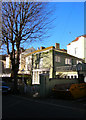
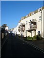
1
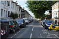
St Aubyns
Built as part of the Cliftonville Estate in the 1830s. Its sole claim to fame is that Virginia Woolf spent a couple of summers living at number 9 when a child.
Image: © Simon Carey
Taken: 3 Feb 2007
0.02 miles
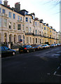
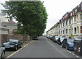
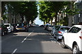
2
Seafield Road, Hove
A residential road connecting Church Road, the B2066, with Kingsway, the A259, that was developed in the 1870s as part of the suburb of Cliftonville. The road is fully developed on the eastern side but contains garages, except for the southern end, on the western side.
Image: © Simon Carey
Taken: 18 Feb 2017
0.02 miles
3
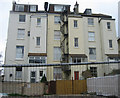
Fire escape - St Aubyns
Redevelopment allows a clear view of the rear of these flats.
Image: © Mr Ignavy
Taken: 29 May 2011
0.03 miles
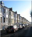
4
Seafield Cottage, Seafield Road
One of three houses that lie on the western side of Seafield Road. The eastern side is of early Victorian terraced housing. The backs of the grander terraces in St Aubyns are behind the cottage. The area between Seafield Road and St Aubyns was a small archery ground in the 1860s.
Image: © Simon Carey
Taken: 3 Feb 2007
0.04 miles
6
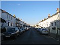
Osborne Villas, Hove
A residential street that links Kingsway, the A259, to Church Road, the B2066, that was developed in the 1850s.
Image: © Simon Carey
Taken: 18 Feb 2017
0.05 miles
7
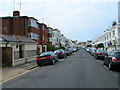
Osborne Villas
Part of the Cliftonville Estate developed in the 1850s.
Image: © Simon Carey
Taken: 1 Jun 2007
0.05 miles
9
Medina Place, Hove
Small mews that connects Hove Place to Osborne Villas that was developed in the 1850s. The road is called Cliftonville Mews on the 1875 OS map but has acquired its current name by the 1898 edition. The flats on the right are Parnell Court named after Charles Stewart Parnell who lived with Kitty O'Shea in nearby Medina Terrace.
Image: © Simon Carey
Taken: 18 Feb 2017
0.07 miles