IMAGES TAKEN NEAR TO
Fourth Avenue, HOVE, BN3 2PJ
Introduction
This page details the photographs taken nearby to Fourth Avenue, BN3 2PJ by members of the Geograph project.
The Geograph project started in 2005 with the aim of publishing, organising and preserving representative images for every square kilometre of Great Britain, Ireland and the Isle of Man.

There are currently over 7.5m images from over14,400 individuals and you can help contribute to the project by visiting https://www.geograph.org.uk
Image Map
Images are licensed for reuse under creativecommons.org/licenses/by-sa/2.0
Notes
- Clicking on the map will re-center to the selected point.
- The higher the marker number, the further away the image location is from the centre of the postcode.
Image Listing (373 Images Found)
Images are licensed for reuse under creativecommons.org/licenses/by-sa/2.0
Image
Details
Distance
1
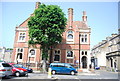
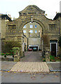
The Hove Club
Grade II listed. http://www.britishlistedbuildings.co.uk/en-365527-hove-club-and-attached-wall-and-railings
Image: © N Chadwick
Taken: 13 Jul 2013
0.02 miles
2
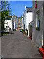
Albany Mews
Small dead end mews between Albany Villas and Fourth Avenue. The rear of the houses in Church Road are straight ahead. The mews would have originally been occupied by tradesman servicing the houses of the upper classes in the newly built Stanford Estate.
Image: © Simon Carey
Taken: 22 Apr 2007
0.02 miles
3
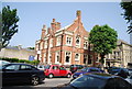
The Hove Club
Grade II listed. http://www.britishlistedbuildings.co.uk/en-365527-hove-club-and-attached-wall-and-railings
Image: © N Chadwick
Taken: 13 Jul 2013
0.03 miles
5
Kings Mews
Currently home to Heathcotes Garage. The far wall has a faded 'Ford' sign painted on it the remains of a previous dealership that operated from this premises.
Image: © Simon Carey
Taken: 26 Nov 2006
0.03 miles
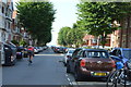
7
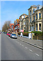
Fourth Avenue
This is the eastern side of the road that links Kingsway (A259) with Church Road (B2066). Fourth Avenue was part of the Stanford Estate that was the last of the Brighton and Hove coast to be developed. Like Cliftonville slow progress in selling plots and building houses meant that styles changed in the same street let alone different ones. The gables, red bricks being the last to be built. Fourth Avenue like many original higher class streets is wide enough to allow parking on either side of the road, double parking in the middle of the road and a large enough transit way either side for traffic.
Image: © Simon Carey
Taken: 22 Apr 2007
0.05 miles
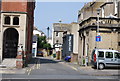
8
The Juggler, Hove Town Hall
The original 1882 building by Alfred Waterhouse was partly destroyed by a fire in 1966. The rest continued to function until the law courts moved to its new position in 1971 and was subsequently demolished too. The new building was completed and opened in 1974. The sculpture of a juggler on a unicycle is by Helen Collis. Ironically, the sign on the lamp post bars the use of bicycles in this area.
Image: © Simon Carey
Taken: 26 Nov 2006
0.05 miles
9
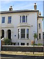
30 Albany Villas
The home of Rear Admiral Sir John Hindmarsh, founding Governor of South Australia. Lived at 30 Albany Villas, Hove. 1857-1859.
Image: © The Saunterer
Taken: 28 Dec 2013
0.05 miles
10
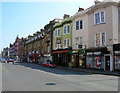
Church Road
Between Albany Villas and Fourth Avenue. The buildings to the right of the Albion Inn were originally part of the Cliftonville development that to the left was initially green fields until the Stanford Estate was developed from the 1890s. Church Road itself follows an old track linking the then small fishing villages of Brighton and Hove but is now one of the two major shopping streets in Hove.
Image: © Simon Carey
Taken: 22 Apr 2007
0.05 miles