IMAGES TAKEN NEAR TO
Second Avenue, HOVE, BN3 2LN
Introduction
This page details the photographs taken nearby to Second Avenue, BN3 2LN by members of the Geograph project.
The Geograph project started in 2005 with the aim of publishing, organising and preserving representative images for every square kilometre of Great Britain, Ireland and the Isle of Man.

There are currently over 7.5m images from over14,400 individuals and you can help contribute to the project by visiting https://www.geograph.org.uk
Image Map
Images are licensed for reuse under creativecommons.org/licenses/by-sa/2.0
Notes
- Clicking on the map will re-center to the selected point.
- The higher the marker number, the further away the image location is from the centre of the postcode.
Image Listing (442 Images Found)
Images are licensed for reuse under creativecommons.org/licenses/by-sa/2.0
Image
Details
Distance
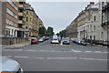
1
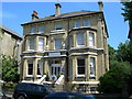
The Claremont Hotel, Second Avenue, Hove, BN3 2LL
This hotel has been a 100% no-smoking establishment for several years. Here is a link to their website http://www.theclaremont.eu/
Image: © Danny P Robinson
Taken: 31 May 2007
0.03 miles
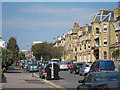

5
Hangover Square
Actually its First Avenue, Hove but the visible blue plaque marks the childhood home of writer Patrick Hamilton creator of the play Rope and novels, Twenty Thousand Streets Under the Sky and Hangover Square itself part of which was set in Brighton. The house with the white around the windows is actually the northern portion of the Imperial Hotel.
Image: © Simon Carey
Taken: 1 Jul 2007
0.05 miles
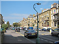
7
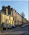
First Avenue, Hove
A view of the eastern side of First Avenue that was constructed during the 1870s. Many of these old townhouses are now subdivided into flats and bedsits.
Image: © Simon Carey
Taken: 9 Apr 2020
0.05 miles
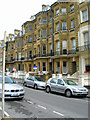
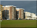
8

Kingsway Court, Queen's Gardens, Kingsway, Hove
The flats occupy the block between First and Second Avenues and were built in the early 1960s. Originally the site of 1-7 Queen's Gardens whose style was similar to neighbouring Image and just as exclusive as the wealthy Sassoon family owned a property here. Between the wars numbers 4-5 became the Kingsway Hotel which eventually extended into the rest of the block after the Second World War by which time number 1 had been hit by a bomb and demolished. The rest was demolished in 1959 to make way for the current building. See http://regencysociety-jamesgray.com/volume12/source/jg_12_026.html for a view taken prior to demolition.
Image: © Simon Carey
Taken: 18 Feb 2017
0.05 miles
9
Sea front buildings, Hove
In the last hour of an otherwise overcast day, the sun finally appears to throw a striking light on Hove sea front buildings.
Image: © Robin Webster
Taken: 29 Mar 2013
0.05 miles
10
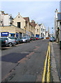
St John's Road
A service road separating the Adelaide Crescent/Palmeira Square developments from the Avenue's estate. The spire of St John's church is in the background.
Image: © Simon Carey
Taken: 1 Jul 2007
0.06 miles