IMAGES TAKEN NEAR TO
Kingsway, HOVE, BN3 2BT
Introduction
This page details the photographs taken nearby to Kingsway, BN3 2BT by members of the Geograph project.
The Geograph project started in 2005 with the aim of publishing, organising and preserving representative images for every square kilometre of Great Britain, Ireland and the Isle of Man.

There are currently over 7.5m images from over14,400 individuals and you can help contribute to the project by visiting https://www.geograph.org.uk
Image Map
Images are licensed for reuse under creativecommons.org/licenses/by-sa/2.0
Notes
- Clicking on the map will re-center to the selected point.
- The higher the marker number, the further away the image location is from the centre of the postcode.
Image Listing (264 Images Found)
Images are licensed for reuse under creativecommons.org/licenses/by-sa/2.0
Image
Details
Distance
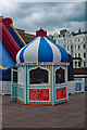
1
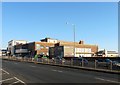
King Alfred Leisure Centre, Kingsway, Hove
The current leisure centre for Hove contains a swimming pool, a small gym (Another larger and privately owned gym can be found within the building complex), a couple of sports hall, an indoor bowls court and a ballroom. The facility itself will in all likely be demolished in the future once a viable redevelopment scheme actually gets off the ground.
The land was originally a playing field for a school from the 1860s and later was used for gravel extraction. During the 1930s Hove council decided it would be an ideal location for a leisure centre that would be called Hove Marina. Work itself did not commence until 1938 then stopped during the Munich Crisis before restarting at the beginning of the following year with an estimated opening date put back to 1940. Most of the building had been completed by August 1939 and some parts had opened to the public, however, when war broke out the following month the complex was requisitioned by the admiralty, whose RNVR was located to the immediate west, see Image, and christened HMS King Alfred. For the next six years it was used as an officers training establishment and finally returned to council ownership in 1945. By then the naval name had stuck and the council decided to retain it for their new facility which opened to the public for the first time in August 1946. The complex's main attraction was the swimming pools which also included those filled with saltwater. These began showing their age in the 1970s and work on an extension on the beach side began in 1980 and opened to the public two years later. Waterslides were added in 1985 and removed in 2009, see Image The small building on the right is the former entrance to the indoor bowling alley which opened in 1960 and closed in 1989.
The site has long been showing its age and redevelopment schemes began as soon as the council acquired the neighbouring RNVR site at the end of the 1960s. Plans for a block of flats were rejected in 1971, that for a hotel in 1981 never got past the drawing board, a 1983 scheme to use public land for a private hospital was thrown out by the council, whilst a 1984 scheme to build an ice rink in glass pyramids remained little more than plans. Between 1989 and 2000 no less than five schemes were drawn up by Citygrove Developments involving mixed leisure and housing developments which failed through a mixture of lack of finance, local opposition, a judicial review applied by a rival cinema chain and the collapse of the company itself. The most notorious of the redevelopment schemes was made public in 2003 with the unveiling of the Gehry towers, four 38 storey blocks designed to look like Edwardian women's dresses. Local opposition was vocal enough to get Gehry to revise the plans and reduce the blocks to two, see https://static-secure.guim.co.uk/sys-images/Society/Pix/pictures/2005/09/14/Gehry.gif . Some surveying work began but the scheme collapsed in 2008 when financial backing was withdrawn due to the recession. A new plan was made public at the beginning of 2016, see https://www.brighton-hove.gov.uk/sites/brighton-hove.gov.uk/files/King%20Alfred%20-%20Sea%20view%20and%20road%20view.png , including the usual mixed leisure facility and housing, which quite naturally, given the history of the site, hit financial and legal problems by the end of the year leading to a six month hiatus.
In the meantime the centre limps on, during the first decade of the 21st century it had not been maintained in readiness for demolition only to have the council inject emergency funding when the Gehry scheme collapsed. The problem with all schemes is one of appeasing local opposition, replacing much needed leisure facilities, providing both upmarket and social housing, and ensuring there are enough parking places for all the new residents and leisure centre users.
Image: © Simon Carey
Taken: 18 Feb 2017
0.00 miles
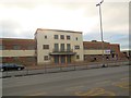
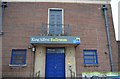
3
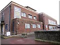
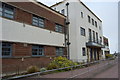
King Alfred Leisure Centre, Hove
Sports centre run by Freedom Leisure http://www.freedom-leisure.co.uk/centres.asp?section=657%A7ionTitle=king+alfred+leisure+centre
Image: © Paul Gillett
Taken: 12 Dec 2013
0.02 miles
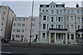
9
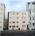
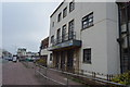
7-8, St Aubyns Gardens, Hove
Located next to ImageNumber 7 in pink was a later addition and number 8, Essex House, appears to have been added in the 1950s on the site of Namrik Lane which led to three cottages behind St Aubyns Gardens that were removed in the 1920s.
Image: © Simon Carey
Taken: 14 Jan 2017
0.03 miles
10
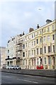
1-6, St Aubyns Gardens, Hove
Built in the 1880s as part of the St Aubyns development despite facing out onto Kingsway, the A259.
Image: © Simon Carey
Taken: 14 Jan 2017
0.03 miles