IMAGES TAKEN NEAR TO
Chatsworth Square, HOVE, BN3 1WE
Introduction
This page details the photographs taken nearby to Chatsworth Square, BN3 1WE by members of the Geograph project.
The Geograph project started in 2005 with the aim of publishing, organising and preserving representative images for every square kilometre of Great Britain, Ireland and the Isle of Man.

There are currently over 7.5m images from over14,400 individuals and you can help contribute to the project by visiting https://www.geograph.org.uk
Image Map
Images are licensed for reuse under creativecommons.org/licenses/by-sa/2.0
Notes
- Clicking on the map will re-center to the selected point.
- The higher the marker number, the further away the image location is from the centre of the postcode.
Image Listing (238 Images Found)
Images are licensed for reuse under creativecommons.org/licenses/by-sa/2.0
Image
Details
Distance
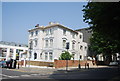
1
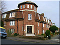
St Ann's Court
Standing on the corner of Somerhill Road and Nizells Avenue and opposite St Ann's Wells Gardens from which it takes its name. Its most famous resident was Lord Alfred Douglas, Oscar Wilde's 'Bosie' who lived here between 1935-44. The flats themselves were built in the early 1930s. This view looks east from Somerhill Road.
Image: © Simon Carey
Taken: 2 Apr 2006
0.04 miles
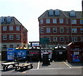
2
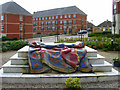
Chatsworth Square
New development built during the 1990s and now occupying the blank space south of the B2120. Prior to this the site had been occupied by a school and a factory which at one point made ice. The sculpture appears to be of a carpet but has no record of what it is called or who it is by (will rectify this as soon as I find out). This view looks south west towards the exit of this cul-de-sac with the houses of Holland Road viewable beyond the entrance.
Image: © Simon Carey
Taken: 2 Apr 2006
0.04 miles
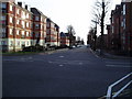
3
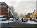
Somerhill Road
Minor road linking Davigdor Road to the north with Lansdowne Road to the south. The Charter Medical Centre is on the right whilst the silver car beyond the crossing pedestrian is having huge problems trying to get out.
Image: © Simon Carey
Taken: 18 Dec 2009
0.04 miles
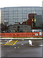
4

Lloyds TSB Building, Davigdor Road
Office building used by Lloyds most likely as computer storage as very few people are ever seen going in or out. The large roof to the right is this Image] whilst the white buildings reflected on the left hand side of the building is on the left hand side of this Image Lyon Close leads to the Peacock Industrial Estate built on a former coal yard rail siding.
Image: © Simon Carey
Taken: 16 Apr 2006
0.05 miles
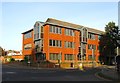
5
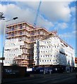
121-123, Davigdor Road, Hove
A block of flats under construction on the corner of Lyon Close. The previous building was a former office block; see Image
Image: © Simon Carey
Taken: 27 Oct 2017
0.05 miles
6
Recycling Point, Davigdor Road
Placed in the car park for Wickes DIY store on the Peacock Industrial Estate.
Image: © Simon Carey
Taken: 7 May 2006
0.05 miles
7
Spitfire House, Davigdor Road, Hove
Located on the corner of Holland Road and built in the 1980s on the site of an old electricity works. The name derives from a story of a plane that crashed into the corner during the Second World War though it appears to have been a Bristol biplane in 1938 which probably wouldn't have sounded so good. After its construction it was used by Nurdin & peacock as a cash and carry then a series of telecom companies until its current occupiers, Marathonbet, moved in a few years ago. I'm guessing the building's primary use is for data storage.
Image: © Simon Carey
Taken: 25 Oct 2015
0.06 miles
8
The Monarch's Way on Holland Road
After proceeding along Cromwell Road the route turns south along Holland Road.
Image: © Peter Holmes
Taken: 26 Jan 2008
0.06 miles
9
Lloyds TSB Building, Davigdor Road
Looking at the eastern side with the Chichester Diocesan Housing Association and Preece House reflected in the glass.
Image: © Simon Carey
Taken: 6 Apr 2008
0.07 miles
10
House on the corner of Somerhill Avenue
Image: © N Chadwick
Taken: 13 Jul 2013
0.07 miles