IMAGES TAKEN NEAR TO
Holland Road, HOVE, BN3 1JY
Introduction
This page details the photographs taken nearby to Holland Road, BN3 1JY by members of the Geograph project.
The Geograph project started in 2005 with the aim of publishing, organising and preserving representative images for every square kilometre of Great Britain, Ireland and the Isle of Man.

There are currently over 7.5m images from over14,400 individuals and you can help contribute to the project by visiting https://www.geograph.org.uk
Image Map
Images are licensed for reuse under creativecommons.org/licenses/by-sa/2.0
Notes
- Clicking on the map will re-center to the selected point.
- The higher the marker number, the further away the image location is from the centre of the postcode.
Image Listing (286 Images Found)
Images are licensed for reuse under creativecommons.org/licenses/by-sa/2.0
Image
Details
Distance
1
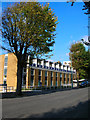
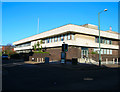
Hove Police Station, Holland Road
Erected in the late 1960s along with the nearby law courts.
Image: © Simon Carey
Taken: 21 Oct 2007
0.01 miles
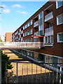
2
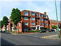
Somerhill Court
On the junction of Somerhill Avenue and Holland Road.
Image: © Simon Carey
Taken: 16 Jul 2006
0.02 miles
3
Glynde House from Holland Road
The rear view of Image taken from Holland Road. The car park in the foreground belongs to Hove Police Station out of picture to the right. The floodlights beyond to Sussex County Cricket Ground.
Image: © Simon Carey
Taken: 21 Oct 2007
0.04 miles
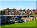
5
Glynde House, Palmeira Avenue
A 60s block of flats on the eastern side of the avenue. This view taken from the drive that leads to the garages at the rear.
Image: © Simon Carey
Taken: 21 Oct 2007
0.04 miles
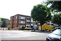
6
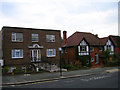
Garden Court, Somerhill Avenue
Another juxtaposition of new and old in this part of home and how the price of land is gradually turning indvidual houses on the right into small blocks of flats on the left.
Image: © Simon Carey
Taken: 16 Apr 2006
0.06 miles
7
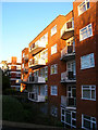
Palmeira House, Palmeira Avenue
One of the many blocks of flats that now line this road, those beyond Palmeira house are Kinsale House.
Image: © Simon Carey
Taken: 17 Dec 2006
0.07 miles
9
Brighton & Hove Reform Synagogue, Palmeira Avenue
There are three synagogues in this square alone reflecting the prominent part played by the Jewish population of the city. Palmeira Avenue is named after a titled bestowed on Sir Isaac Goldsmid, a local landowner who developed this part of the estate, by the Portuguese government. Goldsmid named many roads after members of his family and even today the local council ward for the area is known as Goldsmid. Sir Isaac was also an early proponent of Reform Judaism in the country.
The building as far as I am aware was built in the mid 1950s.
Image: © Simon Carey
Taken: 3 Mar 2007
0.07 miles
10
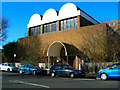
Hove Crown Court
The original court was in the Hove Town Hall complex and initially survived the fire that destroyed the rest of the building in 1966. However, once it was decided to develop the whole town council site this building was built on Lansdowne Road and opened in 1973.
Image: © Simon Carey
Taken: 3 Feb 2007
0.08 miles