IMAGES TAKEN NEAR TO
Holland Road, HOVE, BN3 1JR
Introduction
This page details the photographs taken nearby to Holland Road, BN3 1JR by members of the Geograph project.
The Geograph project started in 2005 with the aim of publishing, organising and preserving representative images for every square kilometre of Great Britain, Ireland and the Isle of Man.

There are currently over 7.5m images from over14,400 individuals and you can help contribute to the project by visiting https://www.geograph.org.uk
Image Map
Images are licensed for reuse under creativecommons.org/licenses/by-sa/2.0
Notes
- Clicking on the map will re-center to the selected point.
- The higher the marker number, the further away the image location is from the centre of the postcode.
Image Listing (255 Images Found)
Images are licensed for reuse under creativecommons.org/licenses/by-sa/2.0
Image
Details
Distance
1
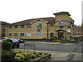
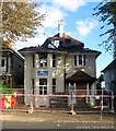
Charter Medical Centre, Davigdor Road
Image: © Stuart Johnson
Taken: 26 Nov 2007
0.02 miles
2
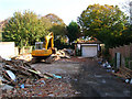
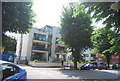
54 Palmeira Avenue
The garage is all that remains of a former bungalow that stood on this site and that too will be demolished soon. The bungalow went because the price of the land it was on outstripped the value of the actual building the result will be similar to Image where a block of flats with its own parking will be erected instead.
Image: © Simon Carey
Taken: 21 Oct 2007
0.03 miles
3
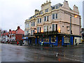
The Palmeira, Cromwell Road
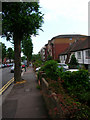
The only pub in the square is on the crossroads of Holland Road and the B2120 with the western portion named Cromwell Road. Built in the 1850s as a hotel to serve the newly opened Hove station up Holland Road to the right. The name derives from the former landowner in the area, Sir Isaac Goldsmid, who at the behest of Queen Victoria assisted in solving a land dispute for the Portuguese government in South America and was awarded the Baronetcy of Palmeira as a reward. This looks in a westerly direction from the crossroads, with part of the building now a corner shop which itself is on the junction of Cromwell Road and Lorna Road.
Image: © Simon Carey
Taken: 19 Feb 2006
0.04 miles
4
Recycling Point, Davigdor Road
Placed in the car park for Wickes DIY store on the Peacock Industrial Estate.
Image: © Simon Carey
Taken: 7 May 2006
0.04 miles
5
CBabies Nursery, Palmeira Avenue, Hove
The house was built in the 1920s and in recent years much had been converted into a nursery with a separate residential dwelling on the top floor. Both were the vicitim of an arson attack on 1 October 2017, thankfully there were no fatalities.
Image: © Simon Carey
Taken: 27 Oct 2017
0.05 miles
6
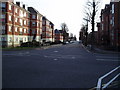
The Monarch's Way on Holland Road
After proceeding along Cromwell Road the route turns south along Holland Road.
Image: © Peter Holmes
Taken: 26 Jan 2008
0.05 miles
8
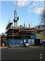
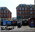
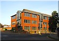
New Development, Palmeira Avenue
Located next door to Image and seven years on from Image when the previous structure was demolished the flats are only just being built. Originally a bungalow with a large garden the rise in house prices and the limitation for expansion within the borough of Brighton & Hove meant the land became worth more than the house itself and was sold for development over a decade ago.
Image: © Simon Carey
Taken: 1 Mar 2014
0.05 miles
9
Amber Court, Holland Road
More juxtaposition of new and not so new and again an indictment of how planning is gradually changing in this square. The long avenues and large plots in Hove leave it ripe for property developers to buy up land containing family houses in order to replace with blocks of flats or apartments. Amber Court was erected in the 1990s on the site of six former houses.
Image: © Simon Carey
Taken: 9 Jul 2006
0.05 miles
10
Spitfire House, Davigdor Road, Hove
Located on the corner of Holland Road and built in the 1980s on the site of an old electricity works. The name derives from a story of a plane that crashed into the corner during the Second World War though it appears to have been a Bristol biplane in 1938 which probably wouldn't have sounded so good. After its construction it was used by Nurdin & peacock as a cash and carry then a series of telecom companies until its current occupiers, Marathonbet, moved in a few years ago. I'm guessing the building's primary use is for data storage.
Image: © Simon Carey
Taken: 25 Oct 2015
0.05 miles