IMAGES TAKEN NEAR TO
Western Road, HOVE, BN3 1FA
Introduction
This page details the photographs taken nearby to Western Road, BN3 1FA by members of the Geograph project.
The Geograph project started in 2005 with the aim of publishing, organising and preserving representative images for every square kilometre of Great Britain, Ireland and the Isle of Man.

There are currently over 7.5m images from over14,400 individuals and you can help contribute to the project by visiting https://www.geograph.org.uk
Image Map
Images are licensed for reuse under creativecommons.org/licenses/by-sa/2.0
Notes
- Clicking on the map will re-center to the selected point.
- The higher the marker number, the further away the image location is from the centre of the postcode.
Image Listing (471 Images Found)
Images are licensed for reuse under creativecommons.org/licenses/by-sa/2.0
Image
Details
Distance
1
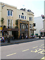
Freemasons, Western Road
Pub and restaurant with a distinct mosaic façade which still retains the name of the original brewery who owned it.
Image: © Simon Carey
Taken: 3 Jun 2007
0.02 miles
2
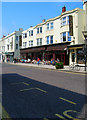
Barneys, Western Road
Takes up the bulk of shop space between Farm Road (to the left) and Brunswick Place (out of picture to the right).
Image: © Simon Carey
Taken: 3 Jun 2007
0.02 miles
3
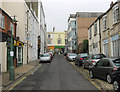
Brunswick Street West
Looking up to the junction with Western Road. The street was built as part of the Brunswick Estate in the 1820s primarily as a service road. To the left is Burger Off a pleasantly named takeaway which lies conveniently near to a pub a few doors up called the Bow Street Runner, which apparently was once the local police station for the newly built Brunswick Estate which had become the Station Inn by the turn of the 20th century. The large building next door to the pub was built in 1855-56 and was the original town hall for Brunswick later becoming Hove's first town hall before that decamped to bigger premises in Church Road. The building is currently used as part of the campus for the Brighton Institute of Modern Music.
Image: © Simon Carey
Taken: 30 Oct 2011
0.03 miles
4
Lansdowne Mews
The entrance is next to the Coopers Cask Pub on Farm Road. Originally stables for the houses in Lansdowne Place, the backs of which are behind, this mews still retains businesses and services and has yet to be converted into housing.
Image: © Simon Carey
Taken: 3 Jun 2007
0.03 miles
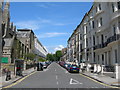
5
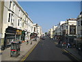
Hove: Western Road
The Freemasons public house is on the right with Brunswick Street West in front of it. Western Road is also the B2066 through here.
Image: © Nigel Cox
Taken: 8 Jun 2008
0.04 miles
6
Brunswick Place
The western side between Western Road and Brunswick Square. Built between 1824-28 by Wilds and Busby originally as a separate estate from Brighton and administered as such an entity until 1875 when it became part of Hove.
Image: © Simon Carey
Taken: 3 Jun 2007
0.04 miles
7
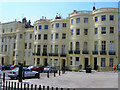
Hove: Brunswick Place
This extension of Brunswick Square north of Western Road is Grade II listed and dates from the middle of the 19th century. The picture was taken on a bright but chilly evening in early April.
Image: © John Sutton
Taken: 7 Apr 2022
0.04 miles
8
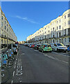
Brunswick Place
Built as part of the Brunswick development between 1824-29. Brunswick Place is the northward extension of Brunswick Square and the houses here were originally intended for the not quite so well off who couldn't afford the apartments by the sea. These days many are subdivided into flats and bedsits. Looking across Western Road, the B2066.
Image: © Simon Carey
Taken: 20 Jul 2009
0.05 miles
9
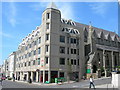
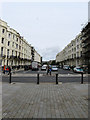
Western Road, Hove
At the corner of Cambridge Road. Showing Sheridan House, 112-116a Western Road, and St Patrick's Church.
Image: © Danny P Robinson
Taken: 31 May 2007
0.05 miles
10
Cambridge Road, Hove
Picture taken from Western Road.
Image: © Danny P Robinson
Taken: 31 May 2007
0.05 miles