IMAGES TAKEN NEAR TO
Lansdowne Road, HOVE, BN3 1DN
Introduction
This page details the photographs taken nearby to Lansdowne Road, BN3 1DN by members of the Geograph project.
The Geograph project started in 2005 with the aim of publishing, organising and preserving representative images for every square kilometre of Great Britain, Ireland and the Isle of Man.

There are currently over 7.5m images from over14,400 individuals and you can help contribute to the project by visiting https://www.geograph.org.uk
Image Map
Images are licensed for reuse under creativecommons.org/licenses/by-sa/2.0
Notes
- Clicking on the map will re-center to the selected point.
- The higher the marker number, the further away the image location is from the centre of the postcode.
Image Listing (377 Images Found)
Images are licensed for reuse under creativecommons.org/licenses/by-sa/2.0
Image
Details
Distance
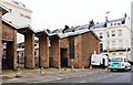
1
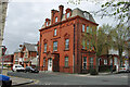
Mercia House, Lansdowne Road / York Road
Image: © Robin Webster
Taken: 30 Apr 2010
0.00 miles
2
Montpelier Place Baptist Church, Brighton
This church's flock is very largely pigeons on the roof, but just one particular part of the roof.
Image: © Robin Webster
Taken: 30 Apr 2010
0.02 miles
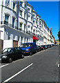
3
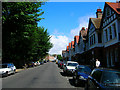
York Avenue
From Furze Hill turn right into the southern part of York Avenue. There is plenty of mock Tudor in this road and others nearby as the road was built up from the early twentieth century onwards.
Click on the link for the next page. http://www.geograph.org.uk/photo/211414
Image: © Simon Carey
Taken: 30 Jul 2006
0.03 miles
4
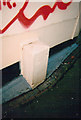
Old Boundary Marker by Boundary Passage, Montpelier Place, Brighton
Parish Boundary Marker by the UC road, in parish of Brighton (Brighton and Hove District), Boundary Passage, at junction with Montpelier Place.
Surveyed
Milestone Society National ID: SX_BNHV02pb
Image: © Milestone Society
Taken: Unknown
0.04 miles
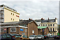
6
Abbey Hotel, Norfolk Terrace
Continue along Montpelier Terrace then turn north into Norfolk Terrace. Another terrace built in the 1830s for the ever expanding town. The Abbey Hotel had a reputation for seediness often letting rooms to those hovering about homelessness. Now it is just a cheap hotel on the edge of the town centre.
Click on the link to take you to the next page. http://www.geograph.org.uk/photo/211794
Image: © Simon Carey
Taken: 30 Jul 2006
0.04 miles
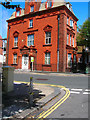
7

A chippy that may have had a former life as a bank
Traditional Fish & Chips the sign says - like it's traditional for a chippy to have once been a bank!
Image: © Slbs
Taken: 13 May 2009
0.04 miles
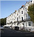
8
Mercia House, Lansdowne Road
At the southern end of York Avenue you come to the junction with Lansdowne Road. We are still in Hove and the red terracotta gothic style recalls some of the big Hove houses to the west. Once a large house Mercia House is now subdivided into flats.
Click on the link to take you to the next page. http://www.geograph.org.uk/photo/211418
Image: © Simon Carey
Taken: 30 Jul 2006
0.05 miles
9

Lansdowne House, Lansdowne Road
On the corner of Lansdowne Road and Brunswick Road the entrance to the house is actually just beyond the road sign. Once a Victorian prep school, one of whose pupils was a 5 year old Winston Churchill, but now a set of flats owned by the YMCA. The houses here are on the northern periphery of Brunswick Town, originally a new town separate from Brighton and Hove. Many of these former town houses are now subdivided into flats.
Image: © Simon Carey
Taken: 2 Apr 2007
0.05 miles
10
Belvedere Terrace, Brighton
Located on the south eastern side of Norfolk Road and built in the late 1840s.
Image: © Simon Carey
Taken: 25 Oct 2015
0.06 miles