1
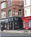
Mercia House, Lansdowne Road
At the southern end of York Avenue you come to the junction with Lansdowne Road. We are still in Hove and the red terracotta gothic style recalls some of the big Hove houses to the west. Once a large house Mercia House is now subdivided into flats.
Click on the link to take you to the next page. http://www.geograph.org.uk/photo/211418
Image: © Simon Carey
Taken: 30 Jul 2006
0.01 miles
2
Old Boundary Marker in Boundary Passage, Brighton and Hove
Parish Boundary Marker by the UC lane, in parish of Brighton (Brighton And Hove District), on the west side of Boundary Passage, halfway along passage.
Surveyed
Milestone Society National ID: SX_BNHV03pb.
Image: © Milestone Society
Taken: Unknown
0.03 miles
3
Brunswick Road, Eastern Side
Brunswick Road connects Lansdowne Road to Western Road and was constructed in the 1850s to provide housing at a lower cost than those in Brunswick Terrace and Square.
Image: © Simon Carey
Taken: 2 Apr 2007
0.03 miles
4
Brunswick Road, Western Side
Built in the 1850s as lower cost housing compared with the opulent town houses in nearby Brunswick Square and Terrace. They are all Grade I listed.
Image: © Simon Carey
Taken: 2 Apr 2007
0.04 miles
5
Hove : Langham Hotel ghost sign, Boundary Passage
Image: © Jim Osley
Taken: 24 Jan 2020
0.05 miles
6
The Providence, Western Road
Drab 1960s building housing offices above whilst the entire lower floor is taken up by a pub which until a few years ago was known as The Lemon Tree.
Image: © Simon Carey
Taken: 2 Apr 2007
0.05 miles
7
Mercia House, Lansdowne Road / York Road
Image: © Robin Webster
Taken: 30 Apr 2010
0.05 miles
8
Old Boundary Marker by Boundary Passage, Montpelier Place, Brighton
Parish Boundary Marker by the UC road, in parish of Brighton (Brighton and Hove District), Boundary Passage, at junction with Montpelier Place.
Surveyed
Milestone Society National ID: SX_BNHV02pb
Image: © Milestone Society
Taken: Unknown
0.05 miles
9
Former Church, Montpelier Terrace
Continue up Temple Street then turn west into Montpelier Terrace. You will then pass what was once St Stephens church. This was opened in 1851 with an interior reconstructed from the Royal Chapel of the Pavilion. It remained a church until 1939 before becoming home to the Sussex Diocese Association of the Deaf and Dumb. Since 1974 it has been a day centre for the homeless run by Free Base.
Click on the link to take you to the next page. http://www.geograph.org.uk/photo/211792
Image: © Simon Carey
Taken: 30 Jul 2006
0.06 miles
10
Boundary Passage
From the junction with Lansdowne Road head south down York Road until you meet Western Road, then turn east. Running parallel with York Road is this twitten which marks the boundary between Brighton and Hove.
Click on the link to go to the next page. http://www.geograph.org.uk/photo/211437
Image: © Simon Carey
Taken: 30 Jul 2006
0.06 miles


