IMAGES TAKEN NEAR TO
Western Road, HOVE, BN3 1DB
Introduction
This page details the photographs taken nearby to Western Road, BN3 1DB by members of the Geograph project.
The Geograph project started in 2005 with the aim of publishing, organising and preserving representative images for every square kilometre of Great Britain, Ireland and the Isle of Man.

There are currently over 7.5m images from over14,400 individuals and you can help contribute to the project by visiting https://www.geograph.org.uk
Image Map
Images are licensed for reuse under creativecommons.org/licenses/by-sa/2.0
Notes
- Clicking on the map will re-center to the selected point.
- The higher the marker number, the further away the image location is from the centre of the postcode.
Image Listing (501 Images Found)
Images are licensed for reuse under creativecommons.org/licenses/by-sa/2.0
Image
Details
Distance
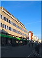
1
The Monarch's Way on Western Road
Looking back along the main thoroughfare towards Hove.
Image: © Peter Holmes
Taken: 26 Jan 2008
0.01 miles
2
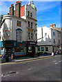
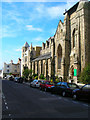
The Juggler, Western Road
The building is early Victorian and has a history of being a hostelry, originally known as the Western Hotel the mosaic of which can be seen above the first floor window, it became O'Reilly's before changing to its current name. The pub and the estate agents next door are the only two buildings between Upper Market Street and Brundwick Street East.
Image: © Simon Carey
Taken: 3 Aug 2007
0.02 miles
4
St. Patrick's, Cambridge Road, Hove
The church has been in Cambridge Road since the 1860's. Further details about the St. Patrick's, especially its recent history can be found here, though recent reports seem to suggest that the night shelter is closing down, though the church remains very much open. http://en.wikipedia.org/wiki/St_Patrick's_Church,_Hove
Image: © nick macneill
Taken: 20 Jan 2012
0.04 miles
5
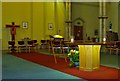
Interior of St. Patrick's, Hove
The church has closed at least for the time being.
Image: © nick macneill
Taken: 30 Aug 2014
0.04 miles
6
Interior of St. Patrick's, Hove
The church has closed at least for the time being.
Image: © nick macneill
Taken: 30 Aug 2014
0.04 miles
7
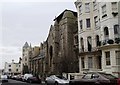
St Patrick's Church, Cambridge Road
Built in 1859 it followed the usual life of a town church until 1985 when the then vicar let two homeless people shelter for the night. Word soon spread about the refuge to the extent that in 1999 part of the church was redeveloped into a hostel and night shelter for the homeless.
Image: © Simon Carey
Taken: 3 Aug 2007
0.04 miles
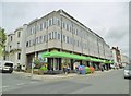
8
Co-Operative, Western Road, Hove
Occupying the ground floor of an office block that was built in the early 1970s between Brunswick Road and York Road. The supermarket moved in around 2011 replacing a former bar called the Providence. Despite the size the store is only a small local one.
Image: © Simon Carey
Taken: 11 Oct 2015
0.04 miles
9
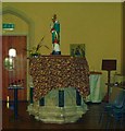
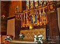
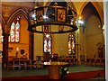
Pulpit and statue, St. Patrick's, Hove
The church has closed at least for the time being.
Although the covered edifice may look like a font it is in fact the original pulpit by G.G. Scott. As I remember it was a fairly mass produced object as one of the saints that surrounded the pulpit was misnamed. The statue above it is of St. Patrick.
Image: © nick macneill
Taken: 30 Aug 2014
0.04 miles