IMAGES TAKEN NEAR TO
Waterloo Street, HOVE, BN3 1AY
Introduction
This page details the photographs taken nearby to Waterloo Street, BN3 1AY by members of the Geograph project.
The Geograph project started in 2005 with the aim of publishing, organising and preserving representative images for every square kilometre of Great Britain, Ireland and the Isle of Man.

There are currently over 7.5m images from over14,400 individuals and you can help contribute to the project by visiting https://www.geograph.org.uk
Image Map
Images are licensed for reuse under creativecommons.org/licenses/by-sa/2.0
Notes
- Clicking on the map will re-center to the selected point.
- The higher the marker number, the further away the image location is from the centre of the postcode.
Image Listing (594 Images Found)
Images are licensed for reuse under creativecommons.org/licenses/by-sa/2.0
Image
Details
Distance
1
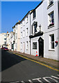
Cross Street
Taken from the former boundary of Brighton and Hove looking into the latter.
Image: © Simon Carey
Taken: 2 Apr 2007
0.02 miles
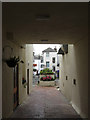
2
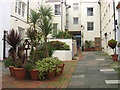
Farman Street
One of the few courtyards of the 19th century that have survived today. Entrance is via a junction in Cross Street or a covered alley onto Western Road which is just visible beyond the covered bin area. As can be seen local residents make an effort to decorate the yard though they are currently trying to gate the northern entrance to avoid drunk ne'er do wells from entering and peeing everywhere plus other even less salubrious activities.
Image: © Simon Carey
Taken: 30 Oct 2011
0.02 miles
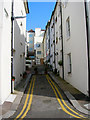
3
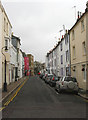
Cross Street
Linking Waterloo Street to Little Western Street.
Image: © Simon Carey
Taken: 30 Oct 2011
0.02 miles
4
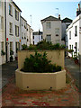
Farman Street
A small courtyard with entrances from Cross Street and Western Road via a covered passageway. The construction in the centre is for bins with small cottages to the west and three storey buildings to the right.
Image: © Simon Carey
Taken: 2 Apr 2007
0.03 miles
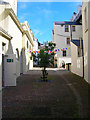
5
Farman Street
This is the view from Cross Street with the passageway to Western Road centre left.
Image: © Simon Carey
Taken: 2 Apr 2007
0.03 miles
6
Farman Street
Small courtyard with a main entrance off Cross Street and passage linking from Western Road. The latter was recently part of a legal battle between the owners of a restaurant on the left and the residents in the street when the former decided to extend their premises onto the path without planning permission. The consequence was that the passage has been under scaffolding for the last few years as the extension was built then stopped for the court case, then demolished as the restaurant owner lost the case. The tiles on the ground denote where the passage was relaid. The flowers in the courtyard are tended to by the residents.
Image: © Simon Carey
Taken: 20 Jul 2009
0.03 miles
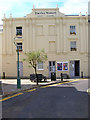
7
The Old Market
Eastern side of the building which is the only part to retain its original single storey structure.
Image: © Simon Carey
Taken: 3 Aug 2007
0.03 miles
8
The Old Market
Purpose built as a market in 1828 by Wills and Busby for the new Brunswick development. The venture did not last long however and was soon being used as a school. It became a riding school in 1850 with the extra stories added in the late 19th century and remained so until after the First World War. It subsequently was used for smoking bacon and ham before becoming the home of a wholesale grocers until 1970. It remained derelict until 1976 when it became an arts centre who themselves folded in 1982 leaving the building derelict once more until 1999 when the building was renovated and reopened as another arts centre which it still is today.
Image: © Simon Carey
Taken: 3 Aug 2007
0.03 miles
9
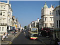
Hove: Western Road
The B2066 Western Road approaching the junction with Cambridge Road to the left and Brunswick Street East to the right. The bus coming the other way is a Number 25 bound for Palmeira Square. Brighton & Hove buses currently name their vehicles after famous but deceased local personalities. This one is Herbert Menges. See http://www.buses.co.uk/frameset.html?history/fleethist/busnamesintro.htm for details.
Image: © Nigel Cox
Taken: 8 Jun 2008
0.03 miles
10
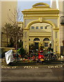
Waterloo Street Arch
Built in 1877 as an entrance to the Old Market building, which can be seen beyond, which by then was being used as a riding school. The arch fell until disrepair after the riding school closed after the First World War but was renovated in the 1980s.
Image: © Simon Carey
Taken: 25 Jan 2014
0.03 miles