1
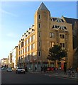
Donkey Mews
The brick buildings at the end of the mews belong to the Regency town houses of Brunswick Square, the mews is a former service road for these houses originally supplying stables for houses and donkeys (hence the name) but now servicing the rear of shops in Western Road.
Image: © Simon Carey
Taken: 3 Aug 2007
0.01 miles
2
Donkey Mews
Small cup de sac off Briunswick Street East originally known as Donkey Row. The houses at the end of this mews front onto Brunswick Square.
Image: © Simon Carey
Taken: 25 Jan 2014
0.01 miles
3
Western Road
Small row of shops between Brunswick Street East and Brunswick Place. Falling between the two centres of Hove and Brighton the shops tend to be small independent outlets, estate and letting agents dominate.
Image: © Simon Carey
Taken: 3 Aug 2007
0.02 miles
4
Sheridan House, Western Road, Hove
Office block located on the corner of Cambridge Road which I think was built in the 1980s.
Image: © Simon Carey
Taken: 11 Oct 2015
0.02 miles
5
The Juggler, Western Road
The building is early Victorian and has a history of being a hostelry, originally known as the Western Hotel the mosaic of which can be seen above the first floor window, it became O'Reilly's before changing to its current name. The pub and the estate agents next door are the only two buildings between Upper Market Street and Brundwick Street East.
Image: © Simon Carey
Taken: 3 Aug 2007
0.03 miles
6
Western Road, Hove
At the corner of Cambridge Road. Showing Sheridan House, 112-116a Western Road, and St Patrick's Church.
Image: © Danny P Robinson
Taken: 31 May 2007
0.03 miles
7
Cambridge Road, Hove
Picture taken from Western Road.
Image: © Danny P Robinson
Taken: 31 May 2007
0.03 miles
8
Brunswick Street East, Hove
Image: © nick macneill
Taken: 20 Jan 2012
0.03 miles
9
St. Patrick's, Cambridge Road, Hove
The church has been in Cambridge Road since the 1860's. Further details about the St. Patrick's, especially its recent history can be found here, though recent reports seem to suggest that the night shelter is closing down, though the church remains very much open. http://en.wikipedia.org/wiki/St_Patrick's_Church,_Hove
Image: © nick macneill
Taken: 20 Jan 2012
0.03 miles
10
Interior of St. Patrick's, Hove
The church has closed at least for the time being.
Image: © nick macneill
Taken: 30 Aug 2014
0.03 miles


