IMAGES TAKEN NEAR TO
Western Road, HOVE, BN3 1AF

Introduction

This page details the photographs taken nearby to Western Road, BN3 1AF by members of the Geograph project.

The Geograph project started in 2005 with the aim of publishing, organising and preserving representative images for every square kilometre of Great Britain, Ireland and the Isle of Man.

There are currently over 7.5m images from over14,400 individuals and you can help contribute to the project by visiting https://www.geograph.org.uk

Image Map


Images are licensed for reuse under creativecommons.org/licenses/by-sa/2.0
Notes
  • Clicking on the map will re-center to the selected point.
  • The higher the marker number, the further away the image location is from the centre of the postcode.

Image Listing (527 Images Found)

Images are licensed for reuse under creativecommons.org/licenses/by-sa/2.0
  • ...
Image
Details
Distance
1
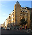
Western Road, Hove
At the corner of Cambridge Road. Showing Sheridan House, 112-116a Western Road, and St Patrick's Church.
Image: © Danny P Robinson Taken: 31 May 2007
0.00 miles
2
Cambridge Road, Hove
Picture taken from Western Road.
Image: © Danny P Robinson Taken: 31 May 2007
0.00 miles
3
Western Road
Small row of shops between Brunswick Street East and Brunswick Place. Falling between the two centres of Hove and Brighton the shops tend to be small independent outlets, estate and letting agents dominate.
Image: © Simon Carey Taken: 3 Aug 2007
0.01 miles
4
Sheridan House, Western Road, Hove
Office block located on the corner of Cambridge Road which I think was built in the 1980s.
Image: © Simon Carey Taken: 11 Oct 2015
0.02 miles
5
Brunswick Place
The western side between Western Road and Brunswick Square. Built between 1824-28 by Wilds and Busby originally as a separate estate from Brighton and administered as such an entity until 1875 when it became part of Hove.
Image: © Simon Carey Taken: 3 Jun 2007
0.02 miles
6
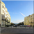
Hove: evening sunlight, Brunswick Place
Looking towards the sea from Western Road on a bright but cold and blustery April evening.
Image: © John Sutton Taken: 7 Apr 2022
0.02 miles
7
Brunswick Place in Hove
Part of the Brunswick Town area of Hove. The houses were built 1824–1830 in the Regency era.
Image: © Mat Fascione Taken: 24 Jun 2024
0.02 miles
8
Brunswick Place, Hove
Image: © Chris Taken: 11 Jun 2016
0.03 miles
9
Donkey Mews
Small cup de sac off Briunswick Street East originally known as Donkey Row. The houses at the end of this mews front onto Brunswick Square.
Image: © Simon Carey Taken: 25 Jan 2014
0.03 miles
10
Donkey Mews
The brick buildings at the end of the mews belong to the Regency town houses of Brunswick Square, the mews is a former service road for these houses originally supplying stables for houses and donkeys (hence the name) but now servicing the rear of shops in Western Road.
Image: © Simon Carey Taken: 3 Aug 2007
0.03 miles
  • ...