IMAGES TAKEN NEAR TO
Phoenix Rise, BRIGHTON, BN2 9WR
Introduction
This page details the photographs taken nearby to Phoenix Rise, BN2 9WR by members of the Geograph project.
The Geograph project started in 2005 with the aim of publishing, organising and preserving representative images for every square kilometre of Great Britain, Ireland and the Isle of Man.

There are currently over 7.5m images from over14,400 individuals and you can help contribute to the project by visiting https://www.geograph.org.uk
Image Map
Images are licensed for reuse under creativecommons.org/licenses/by-sa/2.0
Notes
- Clicking on the map will re-center to the selected point.
- The higher the marker number, the further away the image location is from the centre of the postcode.
Image Listing (502 Images Found)
Images are licensed for reuse under creativecommons.org/licenses/by-sa/2.0
Image
Details
Distance
1
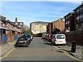
Tamplin Terrace, Brighton
Built in the early 2000s on the site of the former Phoenix Brewery that had opened by Tamplins in 1821 after a fire had destroyed a former brewery in Southwick. Tamplins gradually became the premier brewery in Brighton absorbing other former concerns until they too were taken over by Watney in 1969. It brewed its last beer in 1973 but the premises remained in use as a bottling plant until that too closed in 1991. The buildings were cleared during the 1990s and have now the site contains housing and student accommodation. One of the flats on the right still contain the old Phoenix logo.
Image: © Simon Carey
Taken: 25 Oct 2015
0.02 miles
2
Tamplin Terrace
Head east past the Free Butt then turn north into what was the former brewery and this is one of two streets redeveloped on the former Phoenix site.
Click on the link to take you to the next page. http://www.geograph.org.uk/photo/231589
Image: © Simon Carey
Taken: 1 Sep 2006
0.02 miles
3
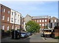
Malthouse Lane, Brighton
A cul de sac off Phoenix Place that was developed in the 1990s mainly in the former gardens of the houses on the left which front onto Lewes Road but also on the former premises of Phoenix Brewery which closed in 1991.
Image: © Simon Carey
Taken: 25 Oct 2015
0.03 miles
4
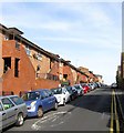
Newhaven Street, Brighton
A residential street that runs between Albion Hill and Southover Street that was originally developed in the early 1850s but was completely cleared in the early 1960s with the western side on the left initially replaced by an extension to Tamplins Phoenix Brewery. Despite closing in 1973 the site was still used as a depot by owners Watney Mann until 1991 when that too was closed and housing was built in its place. See http://regencysociety-jamesgray.com/volume27/source/jg_27_004.html for the same view in 1960.
Image: © Simon Carey
Taken: 25 Oct 2015
0.03 miles
5
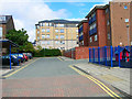
Modern housing on Malthouse Lane
Image: © Oast House Archive
Taken: 11 Sep 2011
0.03 miles
6
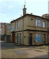
The Free Butt, Phoenix Place, Brighton
Originally the brewery tap for neighbouring Phoenix Brewery which continued as a popular local live music venue until noise complaints forced its closure in 2010. Five years on the pub remains empty, a very sad sight.
Image: © Simon Carey
Taken: 25 Oct 2015
0.04 miles
7
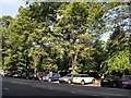
Trees beside the level
Viewed from the Lewes Road on the east side of the level, the early morning sunshine brings out the summer colours
Image: © Paul Gillett
Taken: 22 May 2010
0.04 miles
8
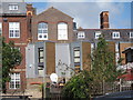
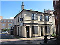
Phoenix Place, Brighton
Originally known as Waterloo Street but named after the former brewery which occupied the site to the immediate north, see Image The brewery ceased production in 1973 but remained in use as a bottling plant until 1991 when it closed for good. All buildings were pulled down with the exception of the former brewery tap, see Image, the building on the left, former offices erected in 1893 and now used as the Phoenix Community Centre and the brick setts in the road. Wellesley House is beyond built in 1970 on a former Regency Terrace and part of the University of Brighton.
Image: © Simon Carey
Taken: 25 Oct 2015
0.05 miles
9
The Freebutt Venue
Closed put on Phoenix Place.
Image: © Oast House Archive
Taken: 11 Sep 2011
0.05 miles
10
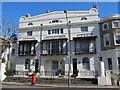
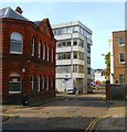
Balconied building, Lewes Road, BN1
Shows the location of Image
Image: © Mike Quinn
Taken: 20 Apr 2012
0.05 miles