IMAGES TAKEN NEAR TO
Southampton Street, BRIGHTON, BN2 9UT
Introduction
This page details the photographs taken nearby to Southampton Street, BN2 9UT by members of the Geograph project.
The Geograph project started in 2005 with the aim of publishing, organising and preserving representative images for every square kilometre of Great Britain, Ireland and the Isle of Man.

There are currently over 7.5m images from over14,400 individuals and you can help contribute to the project by visiting https://www.geograph.org.uk
Image Map
Images are licensed for reuse under creativecommons.org/licenses/by-sa/2.0
Notes
- Clicking on the map will re-center to the selected point.
- The higher the marker number, the further away the image location is from the centre of the postcode.
Image Listing (302 Images Found)
Images are licensed for reuse under creativecommons.org/licenses/by-sa/2.0
Image
Details
Distance
1
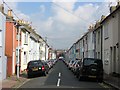
Islingwood Street, Brighton
A residential street in the Hanover district that links Southover Street to Islingwood Road and was developed in the early 1870s.
Image: © Simon Carey
Taken: 4 Oct 2015
0.00 miles
2
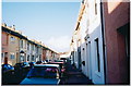
Islingword Street
One of the Terraced Streets of Hanover.
Image: © andrew
Taken: 24 Jun 2002
0.02 miles
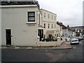
4
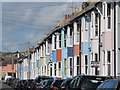
Islingwood Street
A colourful road of terraced houses.
Image: © Oast House Archive
Taken: 16 Oct 2010
0.04 miles
5
Islingword Road
Second building down is the Emmanuel centre built on the site of the former Islingword Road Mission destroyed by fire in May 2003 Image
Image: © Paul Gillett
Taken: 14 Oct 2009
0.04 miles
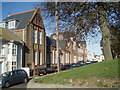
7
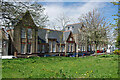
Former Finsbury Road School, Brighton
Erected 1881 for the School Board for Brighton and Preston. It is a grade II listed building. Now put to other uses.
Image: © Robin Webster
Taken: 30 Apr 2010
0.04 miles
8
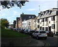
Finsbury Road, Brighton
A residential street that runs between Islingwood road and Southover Street that was developed in the late 1860s. On the right is Finsbury Lodge, a set of flats built sometime in the 1980s on a former garden, whilst to the left is the imposing Hanover Lofts which was built around 1880 as the Finsbury Road Board School. It remained a school until the mid 1950s when it was acquired by Brighton College of Technology, a predecessor of Brighton Polytechnic, and used as its arts and textiles department until the late 1990s. When the building was threatened with demolition it was listed and in 2003 converted into flats. Out of shot to the lefts are a number of flats built on the site of the former Home for Female Penitents.
Image: © Simon Carey
Taken: 25 Oct 2015
0.04 miles
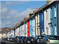
9
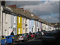
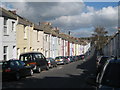
Southampton Road
A colourful road of terraced houses.
Image: © Oast House Archive
Taken: 16 Oct 2010
0.04 miles
10
Finsbury Road
This road runs between Southover Street and Islingword Road and included an annexe of the then Brighton University Faculty of Art and Design
Image: © Paul Gillett
Taken: 26 Oct 2009
0.05 miles