IMAGES TAKEN NEAR TO
Islingword Road, BRIGHTON, BN2 9SX
Introduction
This page details the photographs taken nearby to Islingword Road, BN2 9SX by members of the Geograph project.
The Geograph project started in 2005 with the aim of publishing, organising and preserving representative images for every square kilometre of Great Britain, Ireland and the Isle of Man.

There are currently over 7.5m images from over14,400 individuals and you can help contribute to the project by visiting https://www.geograph.org.uk
Image Map
Images are licensed for reuse under creativecommons.org/licenses/by-sa/2.0
Notes
- Clicking on the map will re-center to the selected point.
- The higher the marker number, the further away the image location is from the centre of the postcode.
Image Listing (261 Images Found)
Images are licensed for reuse under creativecommons.org/licenses/by-sa/2.0
Image
Details
Distance
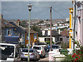
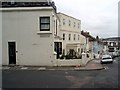
1
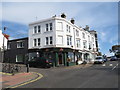
Islingworld Road, Brighton
A parade of shops with flats on the upper floors, on Islingworld Road in the suburbs of Brighton.
Image: © Malc McDonald
Taken: 24 Aug 2019
0.02 miles
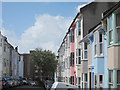
2

Whichelo Place, Brighton
Whichelo Place is a residential street in the suburbs of Brighton.
Image: © Malc McDonald
Taken: 24 Aug 2019
0.02 miles
3
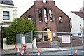
Church destroyed by fire
The former Islingword Road Mission (later renamed Immanuel Family Church) destroyed by fire in May 2003
Image: © Paul Gillett
Taken: 9 May 2003
0.03 miles
4
Toronto Terrace, Brighton
A residential road that runs north from Albion Hill and crosses Southover Street before becoming a dead end. Built in the late 1860s and one of three streets in the vicinity named after places in Canada that had been made a dominion in 1867. On the right is Image
Image: © Simon Carey
Taken: 4 Oct 2015
0.03 miles
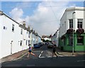
6
Islingwood Place, Brighton
A residential street that runs between bentham Road and Islingwood Road that was developed in the late 1860s.
Image: © Simon Carey
Taken: 25 Oct 2015
0.03 miles
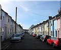
7
Whichelo Place
Colourful residential terrace.
Image: © Oast House Archive
Taken: 11 Sep 2011
0.03 miles
9
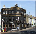
The Islingwood Inn, Queen's Park Road, Brighton
Opened around 1876 as the Beaufort Hotel later becoming the Beaufort Arms and Duke of Beaufort until 2014 when the pub was refurbished and renamed. Located on the corner of Islingwood Road.
Image: © Simon Carey
Taken: 25 Oct 2015
0.04 miles
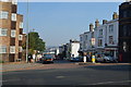
10
Islingword Road
Second building down is the Emmanuel centre built on the site of the former Islingword Road Mission destroyed by fire in May 2003 Image
Image: © Paul Gillett
Taken: 14 Oct 2009
0.04 miles