IMAGES TAKEN NEAR TO
Coleman Street, BRIGHTON, BN2 9SQ
Introduction
This page details the photographs taken nearby to Coleman Street, BN2 9SQ by members of the Geograph project.
The Geograph project started in 2005 with the aim of publishing, organising and preserving representative images for every square kilometre of Great Britain, Ireland and the Isle of Man.

There are currently over 7.5m images from over14,400 individuals and you can help contribute to the project by visiting https://www.geograph.org.uk
Image Map
Images are licensed for reuse under creativecommons.org/licenses/by-sa/2.0
Notes
- Clicking on the map will re-center to the selected point.
- The higher the marker number, the further away the image location is from the centre of the postcode.
Image Listing (326 Images Found)
Images are licensed for reuse under creativecommons.org/licenses/by-sa/2.0
Image
Details
Distance
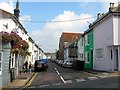
1

Jackson Street, Brighton
A residential street that runs between Ewart Street and Washington Street and was developed in the early 1880s. One of four in the vicinity named after American presidents.
Image: © Simon Carey
Taken: 25 Oct 2015
0.04 miles
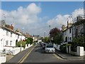
2
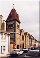
Washington Street, Brighton
A residential street in the Hanover district that runs from Southover Street to Islingwood Road and was developed in the early 1860s. On the left is the Church of the Annunciation built by Henry Wagner as the parish church at roughly the same time as the street itself.
Image: © Simon Carey
Taken: 4 Oct 2015
0.05 miles
3
Lincoln Cottages, Brighton
A cul de sac off Lincoln Street that was developed in the early 1880s. One of a number streets in the vicinity named after American presidents. The properties at the end of the street face onto Ewart Street.
Image: © Simon Carey
Taken: 25 Oct 2015
0.06 miles
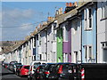
4
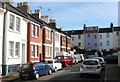
Lincoln Street, Brighton
A residential street in the Hanover district that links Southover Street to Islingwood Road that was developed in the early 1880s. As can be seen parking is a huge issue on these narrow Victorian streets. See also Image from nine years ago.
Image: © Simon Carey
Taken: 4 Oct 2015
0.06 miles
5
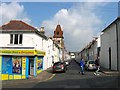
Hanover Street, Brighton
The street runs between Southover Street and Islingwood Road and was built in 1822.
Image: © Simon Carey
Taken: 4 Oct 2015
0.06 miles
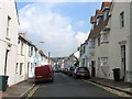
7
Coleman Street, Brighton
A residential street in the Hanover district that runs from Southover Street to Islingwood Road and was developed in the early 1860s. The pub on the left is The Geese whilst the rear of the Church of the Annunciation is on the right.
Image: © Simon Carey
Taken: 4 Oct 2015
0.06 miles
8
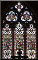
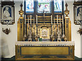
The Annunciation, Brighton - Stained glass window
Image: © John Salmon
Taken: 8 Jul 2017
0.07 miles