IMAGES TAKEN NEAR TO
Hanover Terrace, BRIGHTON, BN2 9SP
Introduction
This page details the photographs taken nearby to Hanover Terrace, BN2 9SP by members of the Geograph project.
The Geograph project started in 2005 with the aim of publishing, organising and preserving representative images for every square kilometre of Great Britain, Ireland and the Isle of Man.

There are currently over 7.5m images from over14,400 individuals and you can help contribute to the project by visiting https://www.geograph.org.uk
Image Map
Images are licensed for reuse under creativecommons.org/licenses/by-sa/2.0
Notes
- Clicking on the map will re-center to the selected point.
- The higher the marker number, the further away the image location is from the centre of the postcode.
Image Listing (339 Images Found)
Images are licensed for reuse under creativecommons.org/licenses/by-sa/2.0
Image
Details
Distance
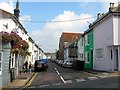
1
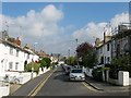
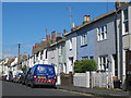
Hanover Street, Brighton
The street runs between Southover Street and Islingwood Road and was built in 1822.
Image: © Simon Carey
Taken: 4 Oct 2015
0.03 miles
2
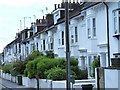
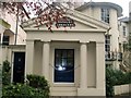
Hanover Crescent
Hanover Crescent consists of 24 houses, it was built in about 1822 by Amon Henry Wilds for Henry Brooker and is Listed at Grade II by English Heritage
Image: © Paul Gillett
Taken: 13 Jan 2012
0.06 miles
4
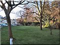
Winter trees by the Level
The level is currently being renovated, large puddles indicate the unusually high amount of rainfall in recent months, The view is from the NE corner across the A270 Lewes Road
Image: © Paul Gillett
Taken: 16 Dec 2012
0.06 miles
6
Washington Street, Brighton
A residential street in the Hanover district that runs from Southover Street to Islingwood Road and was developed in the early 1860s. On the left is the Church of the Annunciation built by Henry Wagner as the parish church at roughly the same time as the street itself.
Image: © Simon Carey
Taken: 4 Oct 2015
0.07 miles
7
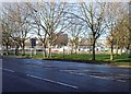
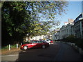
1, Hanover Crescent
At the entrance to the crescent, opposite the level
Image: © Paul Gillett
Taken: 10 Nov 2012
0.07 miles
8
Hanover Crescent
Situated opposite the Level in Central Brighton
Image: © Paul Gillett
Taken: 25 Oct 2009
0.07 miles
9
Coleman Street, Brighton
A residential street in the Hanover district that runs from Southover Street to Islingwood Road and was developed in the early 1860s. The pub on the left is The Geese whilst the rear of the Church of the Annunciation is on the right.
Image: © Simon Carey
Taken: 4 Oct 2015
0.07 miles
10

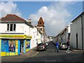
Jackson Street, Brighton
A residential street that runs between Ewart Street and Washington Street and was developed in the early 1880s. One of four in the vicinity named after American presidents.
Image: © Simon Carey
Taken: 25 Oct 2015
0.07 miles