IMAGES TAKEN NEAR TO
Sussex Place, BRIGHTON, BN2 9QN
Introduction
This page details the photographs taken nearby to Sussex Place, BN2 9QN by members of the Geograph project.
The Geograph project started in 2005 with the aim of publishing, organising and preserving representative images for every square kilometre of Great Britain, Ireland and the Isle of Man.

There are currently over 7.5m images from over14,400 individuals and you can help contribute to the project by visiting https://www.geograph.org.uk
Image Map
Images are licensed for reuse under creativecommons.org/licenses/by-sa/2.0
Notes
- Clicking on the map will re-center to the selected point.
- The higher the marker number, the further away the image location is from the centre of the postcode.
Image Listing (801 Images Found)
Images are licensed for reuse under creativecommons.org/licenses/by-sa/2.0
Image
Details
Distance
1
Ivory Place, Brighton
A cul de sac off Morley Street that was developed in the early 1820s and soon became an area of slum housing. The southern end was cleared in the 1930s with threst following in the 1950s and 60s.
Image: © Simon Carey
Taken: 4 Oct 2015
0.02 miles
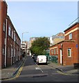
2
Ebeneezer Baptist Chapel, Richmond Parade
Head north along Ashton Rise then south down Richmond Parade. The latter is the former western section of Richmond Street from which it is now cut off from. The chapel was rebuilt in the late 1960s to replace the previous building which had stood on the opposite side of the road from 1825 to 1866. This area was cleared from 1959 onwards and resulted in the construction of five tower blocks as replacements.
Click on the link to take you to the next page. http://www.geograph.org.uk/photo/231516
Image: © Simon Carey
Taken: 1 Sep 2006
0.02 miles
3
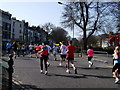
Runners enter Grand Parade
after 4.5 miles of the inaugural Brighton Marathon
Image: © Paul Gillett
Taken: 18 Apr 2010
0.02 miles
4
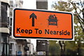
Keep to Nearside
Side prompting those participating in the Veteran car run to keep to the left hand lane, though most ignored it.
Image: © Oast House Archive
Taken: 4 Nov 2012
0.03 miles
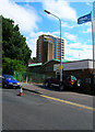
5
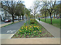
Tulips in Victoria Gardens
The gardens have recently been relaid as part of a major road scheme
Image: © Paul Gillett
Taken: 1 May 2021
0.03 miles
7
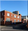
School Clinic, Morley Street, Brighton
Built in 1938 as part of a slum clearance on the lower western side of what was then Sussex Street. Received a direct hit during World War Two that resulted in the deaths of three children. Still used by the NHS today.
Image: © Simon Carey
Taken: 1 Nov 2015
0.04 miles
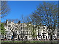
8
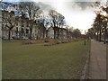
Victoria Gardens
These central gardens were originally a single large, flat, open space which joined the Steine and the Level, and which was usually known as the North Steine http://www.mybrightonandhove.org.uk/category_id__823_path__0p115p203p.aspx
Image: © Paul Gillett
Taken: 2 Jan 2011
0.04 miles
9
Psychosocial, Morley Street, Brighton
The current occupants of this night club since 2012. Its most well known incarnation was as the Ocean Rooms which closed in 2010 after the violent death of a clubber.
Image: © Simon Carey
Taken: 4 Oct 2015
0.04 miles
10
Club Facade in Morley Street, Brighton
Image: © tristan forward
Taken: 9 Nov 2005
0.04 miles